You are here: Home > Network List > TA - USArray Transportable Network (new EarthScope stations) Stations List
> Station Z15A Gila River Indian Community, Laveen, AZ, USA > Earthquake Result Viewer
Z15A Gila River Indian Community, Laveen, AZ, USA - Earthquake Result Viewer
| Earthquake location: |
Tonga Islands |
| Earthquake latitude/longitude: |
-20.8/-173.3 |
| Earthquake time(UTC): |
2008/06/26 (178) 21:19:15 GMT |
| Earthquake Depth: |
38 km |
| Earthquake Magnitude: |
6.0 MB, 5.8 MS, 6.2 MW, 6.1 MW |
| Earthquake Catalog/Contributor: |
WHDF/NEIC |
|
| Network: |
TA USArray Transportable Network (new EarthScope stations) |
| Station: |
Z15A Gila River Indian Community, Laveen, AZ, USA |
| Lat/Lon: |
33.29 N/112.16 W |
| Elevation: |
318 m |
|
| Distance: |
79.3 deg |
| Az: |
48.314 deg |
| Baz: |
236.55 deg |
| Ray Param: |
0.04898041 |
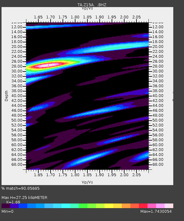
| Estimated Moho Depth: |
27.25 km |
| Estimated Crust Vp/Vs: |
1.69 |
| Assumed Crust Vp: |
6.264 km/s |
| Estimated Crust Vs: |
3.706 km/s |
| Estimated Crust Poisson's Ratio: |
0.23 |
|
| Radial Match: |
90.85665 % |
| Radial Bump: |
400 |
| Transverse Match: |
74.84457 % |
| Transverse Bump: |
400 |
| SOD ConfigId: |
2504 |
| Insert Time: |
2010-03-07 06:06:10.271 +0000 |
| GWidth: |
2.5 |
| Max Bumps: |
400 |
| Tol: |
0.001 |
|

Signal To Noise
| Channel | StoN | STA | LTA |
| TA:Z15A: :BHZ:20080626T21:30:46.275007Z | 15.269586 | 1.602304E-6 | 1.04934344E-7 |
| TA:Z15A: :BHN:20080626T21:30:46.275007Z | 3.7907984 | 4.2146715E-7 | 1.1118163E-7 |
| TA:Z15A: :BHE:20080626T21:30:46.275007Z | 5.167952 | 5.445039E-7 | 1.0536164E-7 |
| Arrivals |
| Ps | 3.1 SECOND |
| PpPs | 11 SECOND |
| PsPs/PpSs | 14 SECOND |


