You are here: Home > Network List > TS - TERRAscope (Southern California Seismic Network) Stations List
> Station PAS Pasadena, California, USA > Earthquake Result Viewer
PAS Pasadena, California, USA - Earthquake Result Viewer

| Earthquake location: |
Hokkaido, Japan Region |
| Earthquake latitude/longitude: |
42.8/139.2 |
| Earthquake time(UTC): |
1993/07/12 (193) 13:17:11 GMT |
| Earthquake Depth: |
17 km |
| Earthquake Magnitude: |
6.7 MB, 7.6 MS, 7.3 UNKNOWN, 7.8 MW |
| Earthquake Catalog/Contributor: |
WHDF/NEIC |
|
| Network: |
TS TERRAscope (Southern California Seismic Network) |
| Station: |
PAS Pasadena, California, USA |
| Lat/Lon: |
34.15 N/118.17 W |
| Elevation: |
295 m |
|
| Distance: |
75.8 deg |
| Az: |
56.618 deg |
| Baz: |
312.221 deg |
| Ray Param: |
0.051426828 |
| Estimated Moho Depth: |
26.25 km |
| Estimated Crust Vp/Vs: |
1.77 |
| Assumed Crust Vp: |
6.1 km/s |
| Estimated Crust Vs: |
3.437 km/s |
| Estimated Crust Poisson's Ratio: |
0.27 |
|
| Radial Match: |
97.44452 % |
| Radial Bump: |
400 |
| Transverse Match: |
92.33417 % |
| Transverse Bump: |
400 |
| SOD ConfigId: |
16938 |
| Insert Time: |
2010-02-26 14:35:22.382 +0000 |
| GWidth: |
2.5 |
| Max Bumps: |
400 |
| Tol: |
0.001 |
|
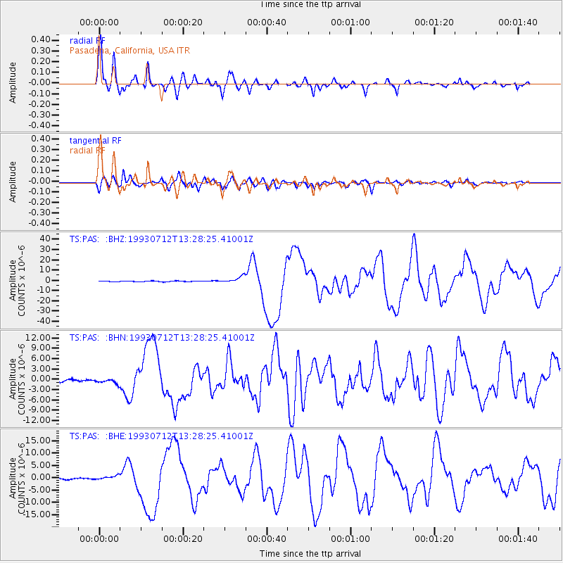
Signal To Noise
| Channel | StoN | STA | LTA |
| TS:PAS: :BHN:19930712T13:28:25.41001Z | 1.5744879 | 7.6067363E-7 | 4.8312444E-7 |
| TS:PAS: :BHE:19930712T13:28:25.41001Z | 2.8836508 | 9.367811E-7 | 3.248594E-7 |
| TS:PAS: :BHZ:19930712T13:28:25.41001Z | 8.690655 | 3.3683748E-6 | 3.8758583E-7 |
| Arrivals |
| Ps | 3.4 SECOND |
| PpPs | 12 SECOND |
| PsPs/PpSs | 15 SECOND |


