You are here: Home > Network List > TX - Texas Seismological Network Stations List
> Station MB01 Midkiff > Earthquake Result Viewer
MB01 Midkiff - Earthquake Result Viewer
| Earthquake location: |
Sea Of Okhotsk |
| Earthquake latitude/longitude: |
53.2/153.7 |
| Earthquake time(UTC): |
2019/11/20 (324) 08:26:07 GMT |
| Earthquake Depth: |
487 km |
| Earthquake Magnitude: |
6.3 Mww |
| Earthquake Catalog/Contributor: |
NEIC PDE/us |
|
| Network: |
TX Texas Seismological Network |
| Station: |
MB01 Midkiff |
| Lat/Lon: |
31.67 N/102.08 W |
| Elevation: |
859 m |
|
| Distance: |
73.1 deg |
| Az: |
59.753 deg |
| Baz: |
322.409 deg |
| Ray Param: |
0.05169692 |
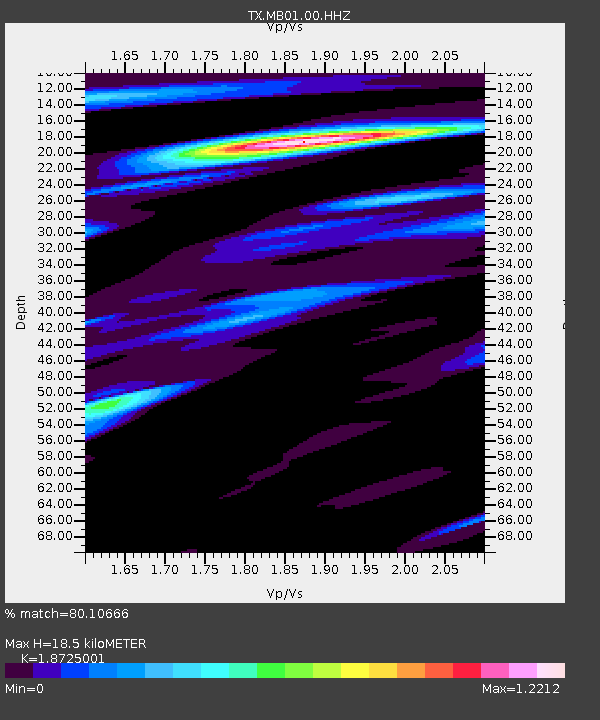
| Estimated Moho Depth: |
18.5 km |
| Estimated Crust Vp/Vs: |
1.87 |
| Assumed Crust Vp: |
6.121 km/s |
| Estimated Crust Vs: |
3.269 km/s |
| Estimated Crust Poisson's Ratio: |
0.30 |
|
| Radial Match: |
80.10666 % |
| Radial Bump: |
400 |
| Transverse Match: |
55.291126 % |
| Transverse Bump: |
400 |
| SOD ConfigId: |
19951751 |
| Insert Time: |
2019-12-04 08:37:45.071 +0000 |
| GWidth: |
2.5 |
| Max Bumps: |
400 |
| Tol: |
0.001 |
|

Signal To Noise
| Channel | StoN | STA | LTA |
| TX:MB01:00:HHZ:20191120T08:36:16.510018Z | 6.165984 | 4.5412642E-7 | 7.365028E-8 |
| TX:MB01:00:HH1:20191120T08:36:16.510018Z | 1.5574195 | 1.243017E-7 | 7.981261E-8 |
| TX:MB01:00:HH2:20191120T08:36:16.510018Z | 1.632783 | 1.6072202E-7 | 9.84344E-8 |
| Arrivals |
| Ps | 2.7 SECOND |
| PpPs | 8.4 SECOND |
| PsPs/PpSs | 11 SECOND |


