You are here: Home > Network List > TX - Texas Seismological Network Stations List
> Station MNHN Monahans > Earthquake Result Viewer
MNHN Monahans - Earthquake Result Viewer
| Earthquake location: |
Sea Of Okhotsk |
| Earthquake latitude/longitude: |
53.2/153.7 |
| Earthquake time(UTC): |
2019/11/20 (324) 08:26:07 GMT |
| Earthquake Depth: |
487 km |
| Earthquake Magnitude: |
6.3 Mww |
| Earthquake Catalog/Contributor: |
NEIC PDE/us |
|
| Network: |
TX Texas Seismological Network |
| Station: |
MNHN Monahans |
| Lat/Lon: |
31.34 N/102.76 W |
| Elevation: |
750 m |
|
| Distance: |
73.0 deg |
| Az: |
60.442 deg |
| Baz: |
322.257 deg |
| Ray Param: |
0.051759206 |
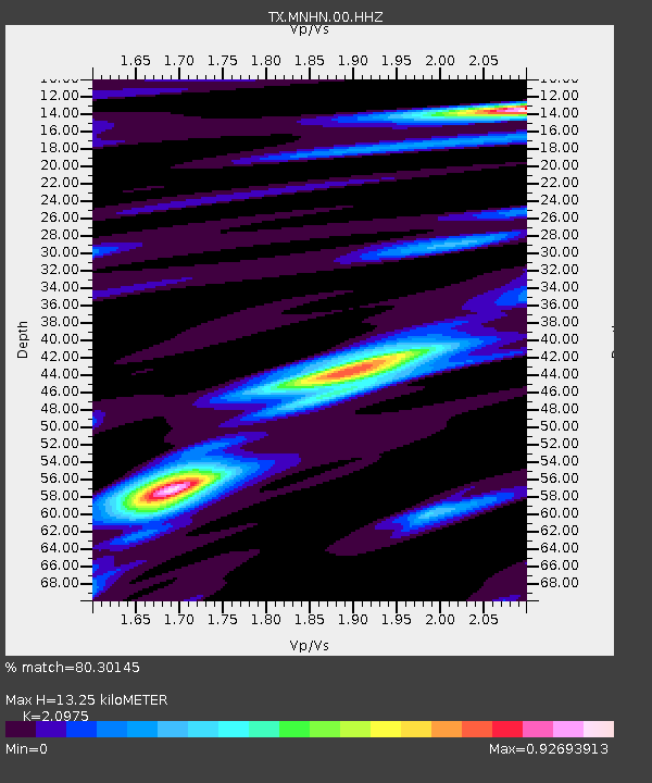
| Estimated Moho Depth: |
13.25 km |
| Estimated Crust Vp/Vs: |
2.10 |
| Assumed Crust Vp: |
6.121 km/s |
| Estimated Crust Vs: |
2.918 km/s |
| Estimated Crust Poisson's Ratio: |
0.35 |
|
| Radial Match: |
80.30145 % |
| Radial Bump: |
400 |
| Transverse Match: |
62.782215 % |
| Transverse Bump: |
400 |
| SOD ConfigId: |
19951751 |
| Insert Time: |
2019-12-04 08:37:48.019 +0000 |
| GWidth: |
2.5 |
| Max Bumps: |
400 |
| Tol: |
0.001 |
|

Signal To Noise
| Channel | StoN | STA | LTA |
| TX:MNHN:00:HHZ:20191120T08:36:15.955025Z | 8.851584 | 9.463126E-7 | 1.0690884E-7 |
| TX:MNHN:00:HH1:20191120T08:36:15.955025Z | 3.72693 | 3.501973E-7 | 9.396402E-8 |
| TX:MNHN:00:HH2:20191120T08:36:15.955025Z | 4.375185 | 4.1345157E-7 | 9.449922E-8 |
| Arrivals |
| Ps | 2.4 SECOND |
| PpPs | 6.5 SECOND |
| PsPs/PpSs | 9.0 SECOND |


