You are here: Home > Network List > US - United States National Seismic Network Stations List
> Station AMTX Amarillo, Texas, USA > Earthquake Result Viewer
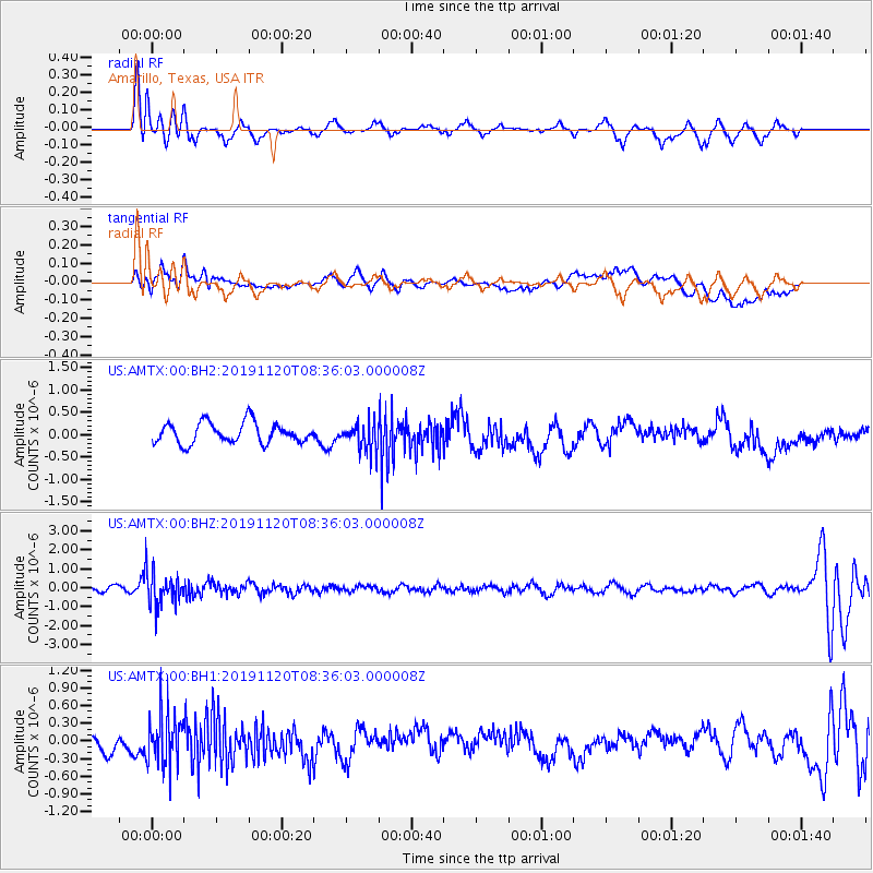
AMTX Amarillo, Texas, USA - Earthquake Result Viewer
*The percent match for this event was below the threshold and hence no stack was calculated.
| Earthquake location: |
Sea Of Okhotsk |
| Earthquake latitude/longitude: |
53.2/153.7 |
| Earthquake time(UTC): |
2019/11/20 (324) 08:26:07 GMT |
| Earthquake Depth: |
487 km |
| Earthquake Magnitude: |
6.3 Mww |
| Earthquake Catalog/Contributor: |
NEIC PDE/us |
|
| Network: |
US United States National Seismic Network |
| Station: |
AMTX Amarillo, Texas, USA |
| Lat/Lon: |
34.53 N/101.41 W |
| Elevation: |
1010 m |
|
| Distance: |
71.2 deg |
| Az: |
57.447 deg |
| Baz: |
322.068 deg |
| Ray Param: |
$rayparam |
*The percent match for this event was below the threshold and hence was not used in the summary stack. |
|
| Radial Match: |
63.129883 % |
| Radial Bump: |
385 |
| Transverse Match: |
33.76096 % |
| Transverse Bump: |
400 |
| SOD ConfigId: |
19951751 |
| Insert Time: |
2019-12-04 08:38:18.382 +0000 |
| GWidth: |
2.5 |
| Max Bumps: |
400 |
| Tol: |
0.001 |
|
Signal To Noise
| Channel | StoN | STA | LTA |
| US:AMTX:00:BHZ:20191120T08:36:03.000008Z | 8.169092 | 8.87058E-7 | 1.08587095E-7 |
| US:AMTX:00:BH1:20191120T08:36:03.000008Z | 2.8968968 | 4.5373162E-7 | 1.5662678E-7 |
| US:AMTX:00:BH2:20191120T08:36:03.000008Z | 2.3440337 | 5.6292686E-7 | 2.4015304E-7 |
| Arrivals |
| Ps | |
| PpPs | |
| PsPs/PpSs | |


