You are here: Home > Network List > TS - TERRAscope (Southern California Seismic Network) Stations List
> Station PAS Pasadena, California, USA > Earthquake Result Viewer
PAS Pasadena, California, USA - Earthquake Result Viewer
| Earthquake location: |
South Of Fiji Islands |
| Earthquake latitude/longitude: |
-23.9/179.8 |
| Earthquake time(UTC): |
1993/08/07 (219) 17:53:27 GMT |
| Earthquake Depth: |
555 km |
| Earthquake Magnitude: |
6.0 MB, 5.9 UNKNOWN, 6.9 MW |
| Earthquake Catalog/Contributor: |
WHDF/NEIC |
|
| Network: |
TS TERRAscope (Southern California Seismic Network) |
| Station: |
PAS Pasadena, California, USA |
| Lat/Lon: |
34.15 N/118.17 W |
| Elevation: |
295 m |
|
| Distance: |
82.4 deg |
| Az: |
47.624 deg |
| Baz: |
234.633 deg |
| Ray Param: |
0.045244645 |
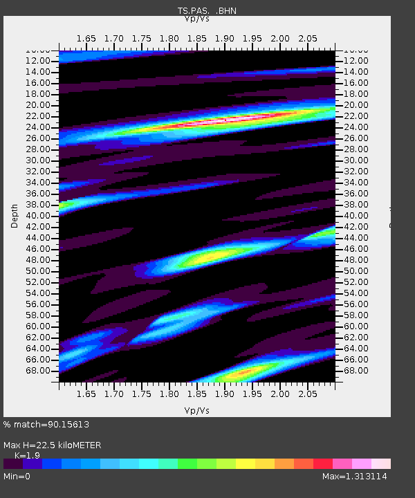
| Estimated Moho Depth: |
22.5 km |
| Estimated Crust Vp/Vs: |
1.90 |
| Assumed Crust Vp: |
6.1 km/s |
| Estimated Crust Vs: |
3.211 km/s |
| Estimated Crust Poisson's Ratio: |
0.31 |
|
| Radial Match: |
90.15613 % |
| Radial Bump: |
400 |
| Transverse Match: |
82.48358 % |
| Transverse Bump: |
400 |
| SOD ConfigId: |
16938 |
| Insert Time: |
2010-02-26 14:35:24.641 +0000 |
| GWidth: |
2.5 |
| Max Bumps: |
400 |
| Tol: |
0.001 |
|
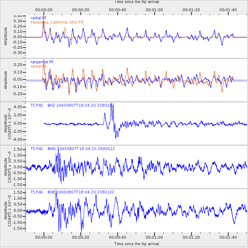
Signal To Noise
| Channel | StoN | STA | LTA |
| TS:PAS: :BHN:19930807T18:04:20.289001Z | 1.8094865 | 2.0635154E-7 | 1.14038734E-7 |
| TS:PAS: :BHE:19930807T18:04:20.338013Z | 2.6947637 | 2.5578134E-7 | 9.491792E-8 |
| TS:PAS: :BHZ:19930807T18:04:20.338013Z | 7.9830723 | 8.696917E-7 | 1.08941975E-7 |
| Arrivals |
| Ps | 3.4 SECOND |
| PpPs | 10 SECOND |
| PsPs/PpSs | 14 SECOND |


