You are here: Home > Network List > TS - TERRAscope (Southern California Seismic Network) Stations List
> Station PAS Pasadena, California, USA > Earthquake Result Viewer
PAS Pasadena, California, USA - Earthquake Result Viewer
| Earthquake location: |
Hokkaido, Japan Region |
| Earthquake latitude/longitude: |
42.0/139.9 |
| Earthquake time(UTC): |
1993/08/07 (219) 19:42:43 GMT |
| Earthquake Depth: |
26 km |
| Earthquake Magnitude: |
6.2 MB, 6.0 MS, 5.6 UNKNOWN, 6.3 MW |
| Earthquake Catalog/Contributor: |
WHDF/NEIC |
|
| Network: |
TS TERRAscope (Southern California Seismic Network) |
| Station: |
PAS Pasadena, California, USA |
| Lat/Lon: |
34.15 N/118.17 W |
| Elevation: |
295 m |
|
| Distance: |
75.9 deg |
| Az: |
56.78 deg |
| Baz: |
311.203 deg |
| Ray Param: |
0.051337153 |
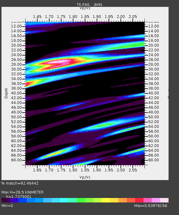
| Estimated Moho Depth: |
26.5 km |
| Estimated Crust Vp/Vs: |
1.74 |
| Assumed Crust Vp: |
6.1 km/s |
| Estimated Crust Vs: |
3.511 km/s |
| Estimated Crust Poisson's Ratio: |
0.25 |
|
| Radial Match: |
92.46442 % |
| Radial Bump: |
400 |
| Transverse Match: |
84.29374 % |
| Transverse Bump: |
400 |
| SOD ConfigId: |
16938 |
| Insert Time: |
2010-02-26 14:35:26.022 +0000 |
| GWidth: |
2.5 |
| Max Bumps: |
400 |
| Tol: |
0.001 |
|
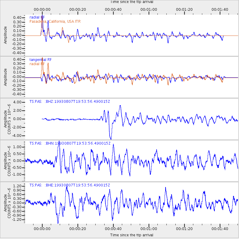
Signal To Noise
| Channel | StoN | STA | LTA |
| TS:PAS: :BHN:19930807T19:53:56.490015Z | 1.0476334 | 9.757028E-8 | 9.313399E-8 |
| TS:PAS: :BHE:19930807T19:53:56.490015Z | 1.3959794 | 1.6889426E-7 | 1.2098621E-7 |
| TS:PAS: :BHZ:19930807T19:53:56.490015Z | 4.797605 | 4.8059724E-7 | 1.001744E-7 |
| Arrivals |
| Ps | 3.3 SECOND |
| PpPs | 12 SECOND |
| PsPs/PpSs | 15 SECOND |


