You are here: Home > Network List > UW - Pacific Northwest Regional Seismic Network Stations List
> Station LEBA Lebam, WA, USA > Earthquake Result Viewer
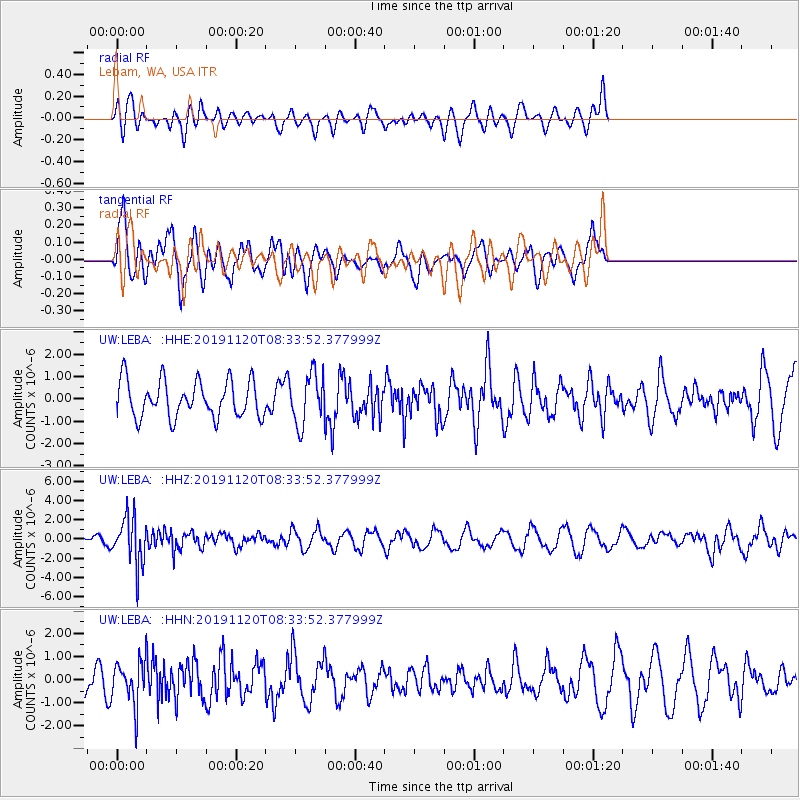
LEBA Lebam, WA, USA - Earthquake Result Viewer
*The percent match for this event was below the threshold and hence no stack was calculated.
| Earthquake location: |
Sea Of Okhotsk |
| Earthquake latitude/longitude: |
53.2/153.7 |
| Earthquake time(UTC): |
2019/11/20 (324) 08:26:07 GMT |
| Earthquake Depth: |
487 km |
| Earthquake Magnitude: |
6.3 Mww |
| Earthquake Catalog/Contributor: |
NEIC PDE/us |
|
| Network: |
UW Pacific Northwest Regional Seismic Network |
| Station: |
LEBA Lebam, WA, USA |
| Lat/Lon: |
46.55 N/123.56 W |
| Elevation: |
73 m |
|
| Distance: |
50.9 deg |
| Az: |
61.862 deg |
| Baz: |
309.711 deg |
| Ray Param: |
$rayparam |
*The percent match for this event was below the threshold and hence was not used in the summary stack. |
|
| Radial Match: |
54.377213 % |
| Radial Bump: |
400 |
| Transverse Match: |
54.41093 % |
| Transverse Bump: |
400 |
| SOD ConfigId: |
19951751 |
| Insert Time: |
2019-12-04 08:39:15.835 +0000 |
| GWidth: |
2.5 |
| Max Bumps: |
400 |
| Tol: |
0.001 |
|
Signal To Noise
| Channel | StoN | STA | LTA |
| UW:LEBA: :HHZ:20191120T08:33:52.377999Z | 2.9260898 | 2.4782723E-6 | 8.4695705E-7 |
| UW:LEBA: :HHN:20191120T08:33:52.377999Z | 1.1087905 | 9.0866087E-7 | 8.1950634E-7 |
| UW:LEBA: :HHE:20191120T08:33:52.377999Z | 1.3934274 | 1.1433609E-6 | 8.205386E-7 |
| Arrivals |
| Ps | |
| PpPs | |
| PsPs/PpSs | |


