You are here: Home > Network List > UW - Pacific Northwest Regional Seismic Network Stations List
> Station UMAT Pilot Rock, OR, USA > Earthquake Result Viewer
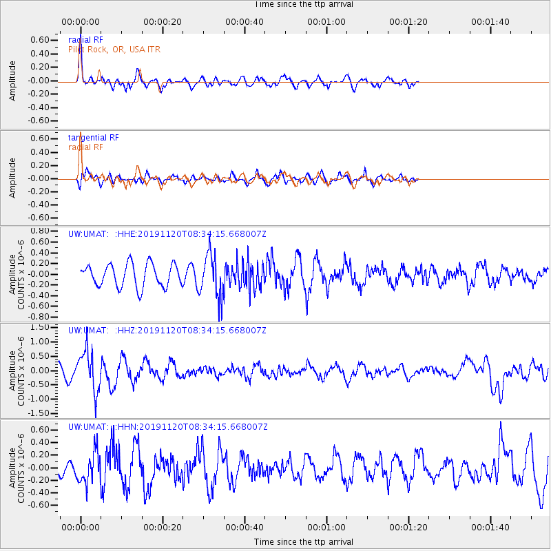
UMAT Pilot Rock, OR, USA - Earthquake Result Viewer
*The percent match for this event was below the threshold and hence no stack was calculated.
| Earthquake location: |
Sea Of Okhotsk |
| Earthquake latitude/longitude: |
53.2/153.7 |
| Earthquake time(UTC): |
2019/11/20 (324) 08:26:07 GMT |
| Earthquake Depth: |
487 km |
| Earthquake Magnitude: |
6.3 Mww |
| Earthquake Catalog/Contributor: |
NEIC PDE/us |
|
| Network: |
UW Pacific Northwest Regional Seismic Network |
| Station: |
UMAT Pilot Rock, OR, USA |
| Lat/Lon: |
45.29 N/118.96 W |
| Elevation: |
1318 m |
|
| Distance: |
54.2 deg |
| Az: |
60.406 deg |
| Baz: |
312.123 deg |
| Ray Param: |
$rayparam |
*The percent match for this event was below the threshold and hence was not used in the summary stack. |
|
| Radial Match: |
73.232834 % |
| Radial Bump: |
400 |
| Transverse Match: |
65.88066 % |
| Transverse Bump: |
400 |
| SOD ConfigId: |
19951751 |
| Insert Time: |
2019-12-04 08:39:22.924 +0000 |
| GWidth: |
2.5 |
| Max Bumps: |
400 |
| Tol: |
0.001 |
|
Signal To Noise
| Channel | StoN | STA | LTA |
| UW:UMAT: :HHZ:20191120T08:34:15.668007Z | 1.9817597 | 7.1632195E-7 | 3.6145752E-7 |
| UW:UMAT: :HHN:20191120T08:34:15.668007Z | 1.0940287 | 2.4814676E-7 | 2.2681925E-7 |
| UW:UMAT: :HHE:20191120T08:34:15.668007Z | 1.8765072 | 3.966848E-7 | 2.113953E-7 |
| Arrivals |
| Ps | |
| PpPs | |
| PsPs/PpSs | |


