You are here: Home > Network List > TS - TERRAscope (Southern California Seismic Network) Stations List
> Station PAS Pasadena, California, USA > Earthquake Result Viewer
PAS Pasadena, California, USA - Earthquake Result Viewer
| Earthquake location: |
San Juan Province, Argentina |
| Earthquake latitude/longitude: |
-31.7/-68.2 |
| Earthquake time(UTC): |
1993/10/30 (303) 17:59:02 GMT |
| Earthquake Depth: |
109 km |
| Earthquake Magnitude: |
5.9 MB, 6.3 UNKNOWN |
| Earthquake Catalog/Contributor: |
WHDF/NEIC |
|
| Network: |
TS TERRAscope (Southern California Seismic Network) |
| Station: |
PAS Pasadena, California, USA |
| Lat/Lon: |
34.15 N/118.17 W |
| Elevation: |
295 m |
|
| Distance: |
80.7 deg |
| Az: |
319.949 deg |
| Baz: |
138.623 deg |
| Ray Param: |
0.047867205 |
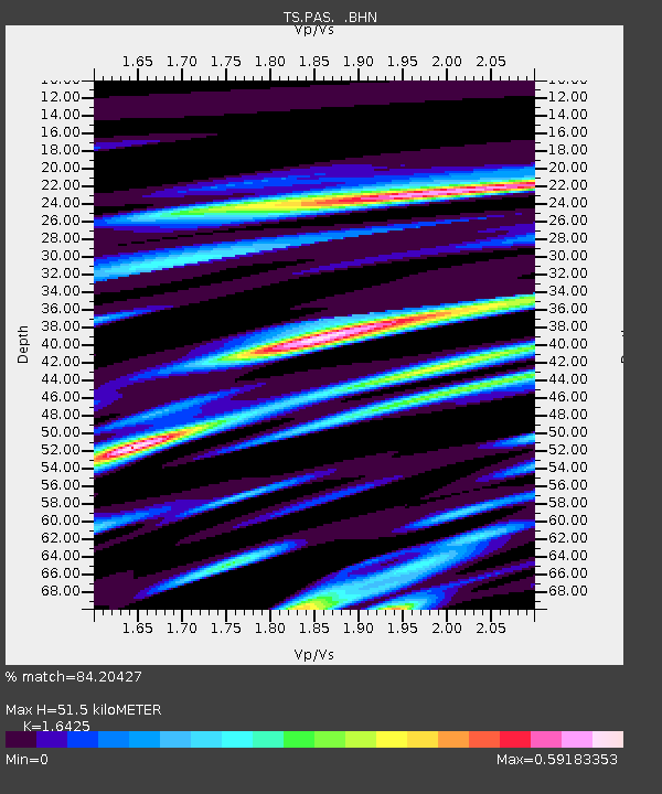
| Estimated Moho Depth: |
51.5 km |
| Estimated Crust Vp/Vs: |
1.64 |
| Assumed Crust Vp: |
6.1 km/s |
| Estimated Crust Vs: |
3.714 km/s |
| Estimated Crust Poisson's Ratio: |
0.21 |
|
| Radial Match: |
84.20427 % |
| Radial Bump: |
349 |
| Transverse Match: |
58.621693 % |
| Transverse Bump: |
400 |
| SOD ConfigId: |
16938 |
| Insert Time: |
2010-02-26 14:35:31.034 +0000 |
| GWidth: |
2.5 |
| Max Bumps: |
400 |
| Tol: |
0.001 |
|
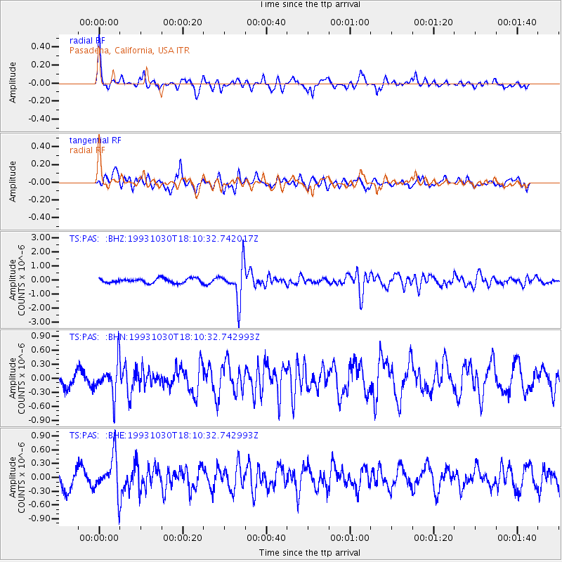
Signal To Noise
| Channel | StoN | STA | LTA |
| TS:PAS: :BHN:19931030T18:10:32.742993Z | 2.4921122 | 3.6881136E-7 | 1.4799149E-7 |
| TS:PAS: :BHE:19931030T18:10:32.742993Z | 2.2764418 | 4.2671837E-7 | 1.8744971E-7 |
| TS:PAS: :BHZ:19931030T18:10:32.742017Z | 8.167314 | 1.3245731E-6 | 1.6217977E-7 |
| Arrivals |
| Ps | 5.6 SECOND |
| PpPs | 22 SECOND |
| PsPs/PpSs | 27 SECOND |


