You are here: Home > Network List > TS - TERRAscope (Southern California Seismic Network) Stations List
> Station PAS Pasadena, California, USA > Earthquake Result Viewer
PAS Pasadena, California, USA - Earthquake Result Viewer
| Earthquake location: |
Unimak Island Region, Alaska |
| Earthquake latitude/longitude: |
54.3/-164.2 |
| Earthquake time(UTC): |
1993/11/19 (323) 01:43:23 GMT |
| Earthquake Depth: |
31 km |
| Earthquake Magnitude: |
6.2 MB, 6.3 MS |
| Earthquake Catalog/Contributor: |
WHDF/NEIC |
|
| Network: |
TS TERRAscope (Southern California Seismic Network) |
| Station: |
PAS Pasadena, California, USA |
| Lat/Lon: |
34.15 N/118.17 W |
| Elevation: |
295 m |
|
| Distance: |
37.8 deg |
| Az: |
103.095 deg |
| Baz: |
316.468 deg |
| Ray Param: |
0.07588315 |
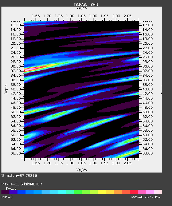
| Estimated Moho Depth: |
31.5 km |
| Estimated Crust Vp/Vs: |
1.60 |
| Assumed Crust Vp: |
6.1 km/s |
| Estimated Crust Vs: |
3.812 km/s |
| Estimated Crust Poisson's Ratio: |
0.18 |
|
| Radial Match: |
87.78316 % |
| Radial Bump: |
389 |
| Transverse Match: |
53.753666 % |
| Transverse Bump: |
400 |
| SOD ConfigId: |
16938 |
| Insert Time: |
2010-02-26 14:35:32.904 +0000 |
| GWidth: |
2.5 |
| Max Bumps: |
400 |
| Tol: |
0.001 |
|
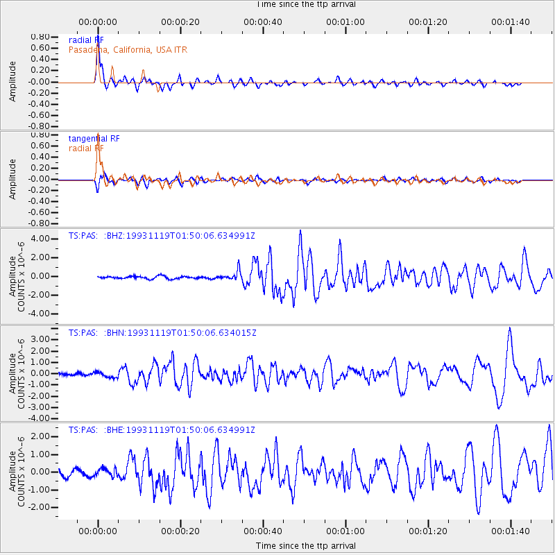
Signal To Noise
| Channel | StoN | STA | LTA |
| TS:PAS: :BHN:19931119T01:50:06.634015Z | 1.4490924 | 2.5459715E-7 | 1.7569421E-7 |
| TS:PAS: :BHE:19931119T01:50:06.634991Z | 1.0987518 | 2.1821387E-7 | 1.986016E-7 |
| TS:PAS: :BHZ:19931119T01:50:06.634991Z | 3.8326325 | 5.074148E-7 | 1.3239328E-7 |
| Arrivals |
| Ps | 3.3 SECOND |
| PpPs | 12 SECOND |
| PsPs/PpSs | 16 SECOND |


