You are here: Home > Network List > GS - US Geological Survey Networks Stations List
> Station KAN09 East Station, Caldwell, KS, USA > Earthquake Result Viewer
KAN09 East Station, Caldwell, KS, USA - Earthquake Result Viewer
| Earthquake location: |
Near Coast Of Central Chile |
| Earthquake latitude/longitude: |
-30.4/-71.5 |
| Earthquake time(UTC): |
2017/03/13 (072) 15:05:55 GMT |
| Earthquake Depth: |
42 km |
| Earthquake Magnitude: |
5.3 mb |
| Earthquake Catalog/Contributor: |
NEIC PDE/us |
|
| Network: |
GS US Geological Survey Networks |
| Station: |
KAN09 East Station, Caldwell, KS, USA |
| Lat/Lon: |
37.14 N/97.62 W |
| Elevation: |
371 m |
|
| Distance: |
71.5 deg |
| Az: |
338.196 deg |
| Baz: |
156.331 deg |
| Ray Param: |
0.05418568 |
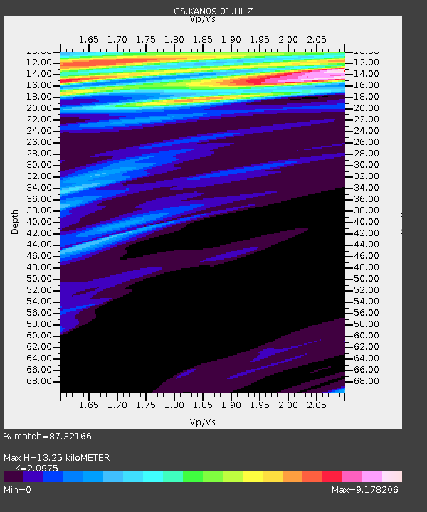
| Estimated Moho Depth: |
13.25 km |
| Estimated Crust Vp/Vs: |
2.10 |
| Assumed Crust Vp: |
6.483 km/s |
| Estimated Crust Vs: |
3.091 km/s |
| Estimated Crust Poisson's Ratio: |
0.35 |
|
| Radial Match: |
87.32166 % |
| Radial Bump: |
400 |
| Transverse Match: |
91.49433 % |
| Transverse Bump: |
324 |
| SOD ConfigId: |
1992691 |
| Insert Time: |
2017-03-27 15:07:54.701 +0000 |
| GWidth: |
2.5 |
| Max Bumps: |
400 |
| Tol: |
0.001 |
|

Signal To Noise
| Channel | StoN | STA | LTA |
| GS:KAN09:01:HHZ:20170313T15:16:41.143977Z | 1.1897918 | 2.7099939E-6 | 2.2777044E-6 |
| GS:KAN09:01:HHN:20170313T15:16:41.143977Z | 1.2500608 | 8.242063E-6 | 6.59333E-6 |
| GS:KAN09:01:HHE:20170313T15:16:41.143977Z | 1.5214534 | 6.805758E-5 | 4.4731954E-5 |
| Arrivals |
| Ps | 2.3 SECOND |
| PpPs | 6.1 SECOND |
| PsPs/PpSs | 8.5 SECOND |


