You are here: Home > Network List > TS - TERRAscope (Southern California Seismic Network) Stations List
> Station PAS Pasadena, California, USA > Earthquake Result Viewer
PAS Pasadena, California, USA - Earthquake Result Viewer

| Earthquake location: |
Peru-Bolivia Border Region |
| Earthquake latitude/longitude: |
-13.3/-69.4 |
| Earthquake time(UTC): |
1994/01/10 (010) 15:53:49 GMT |
| Earthquake Depth: |
589 km |
| Earthquake Magnitude: |
6.4 MB, 6.4 UNKNOWN, 6.9 MW |
| Earthquake Catalog/Contributor: |
WHDF/NEIC |
|
| Network: |
TS TERRAscope (Southern California Seismic Network) |
| Station: |
PAS Pasadena, California, USA |
| Lat/Lon: |
34.15 N/118.17 W |
| Elevation: |
295 m |
|
| Distance: |
66.2 deg |
| Az: |
316.997 deg |
| Baz: |
126.815 deg |
| Ray Param: |
0.055640228 |
| Estimated Moho Depth: |
20.25 km |
| Estimated Crust Vp/Vs: |
2.05 |
| Assumed Crust Vp: |
6.1 km/s |
| Estimated Crust Vs: |
2.979 km/s |
| Estimated Crust Poisson's Ratio: |
0.34 |
|
| Radial Match: |
93.27084 % |
| Radial Bump: |
400 |
| Transverse Match: |
82.786354 % |
| Transverse Bump: |
400 |
| SOD ConfigId: |
16938 |
| Insert Time: |
2010-02-26 14:35:33.960 +0000 |
| GWidth: |
2.5 |
| Max Bumps: |
400 |
| Tol: |
0.001 |
|
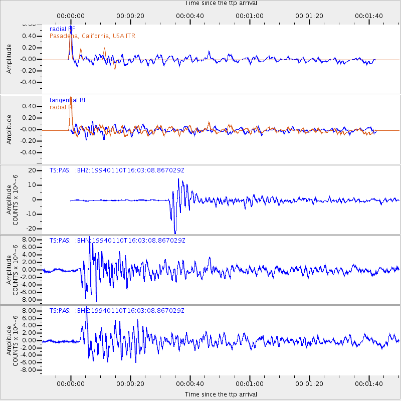
Signal To Noise
| Channel | StoN | STA | LTA |
| TS:PAS: :BHN:19940110T16:03:08.867029Z | 4.848071 | 1.3729826E-6 | 2.8320184E-7 |
| TS:PAS: :BHE:19940110T16:03:08.867029Z | 7.6945477 | 1.3884444E-6 | 1.8044523E-7 |
| TS:PAS: :BHZ:19940110T16:03:08.867029Z | 22.98932 | 5.204437E-6 | 2.2638497E-7 |
| Arrivals |
| Ps | 3.6 SECOND |
| PpPs | 9.8 SECOND |
| PsPs/PpSs | 13 SECOND |


