You are here: Home > Network List > IW - Intermountain West Stations List
> Station MOOW Moose Ponds, Wyoming, USA > Earthquake Result Viewer
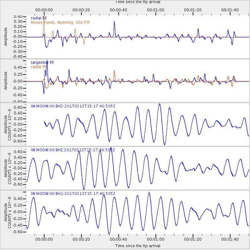
MOOW Moose Ponds, Wyoming, USA - Earthquake Result Viewer
*The percent match for this event was below the threshold and hence no stack was calculated.
| Earthquake location: |
Near Coast Of Central Chile |
| Earthquake latitude/longitude: |
-30.4/-71.5 |
| Earthquake time(UTC): |
2017/03/13 (072) 15:05:55 GMT |
| Earthquake Depth: |
42 km |
| Earthquake Magnitude: |
5.3 mb |
| Earthquake Catalog/Contributor: |
NEIC PDE/us |
|
| Network: |
IW Intermountain West |
| Station: |
MOOW Moose Ponds, Wyoming, USA |
| Lat/Lon: |
43.75 N/110.74 W |
| Elevation: |
2128 m |
|
| Distance: |
82.1 deg |
| Az: |
332.403 deg |
| Baz: |
146.486 deg |
| Ray Param: |
$rayparam |
*The percent match for this event was below the threshold and hence was not used in the summary stack. |
|
| Radial Match: |
52.136963 % |
| Radial Bump: |
347 |
| Transverse Match: |
85.39688 % |
| Transverse Bump: |
385 |
| SOD ConfigId: |
1992691 |
| Insert Time: |
2017-03-27 15:08:59.651 +0000 |
| GWidth: |
2.5 |
| Max Bumps: |
400 |
| Tol: |
0.001 |
|
Signal To Noise
| Channel | StoN | STA | LTA |
| IW:MOOW:00:BHZ:20170313T15:17:40.505Z | 0.767637 | 2.6318307E-7 | 3.4284832E-7 |
| IW:MOOW:00:BH1:20170313T15:17:40.505Z | 0.2444161 | 7.984816E-8 | 3.2668942E-7 |
| IW:MOOW:00:BH2:20170313T15:17:40.505Z | 1.9037535 | 3.5728172E-7 | 1.8767226E-7 |
| Arrivals |
| Ps | |
| PpPs | |
| PsPs/PpSs | |


