You are here: Home > Network List > TA - USArray Transportable Network (new EarthScope stations) Stations List
> Station G25A Newell, SD, USA > Earthquake Result Viewer
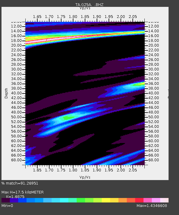
G25A Newell, SD, USA - Earthquake Result Viewer
| Earthquake location: |
Off Coast Of Costa Rica |
| Earthquake latitude/longitude: |
7.9/-85.6 |
| Earthquake time(UTC): |
2009/08/13 (225) 09:37:35 GMT |
| Earthquake Depth: |
10 km |
| Earthquake Magnitude: |
5.8 MW, 5.3 MB |
| Earthquake Catalog/Contributor: |
WHDF/NEIC |
|
| Network: |
TA USArray Transportable Network (new EarthScope stations) |
| Station: |
G25A Newell, SD, USA |
| Lat/Lon: |
45.19 N/103.42 W |
| Elevation: |
894 m |
|
| Distance: |
40.2 deg |
| Az: |
340.442 deg |
| Baz: |
152.034 deg |
| Ray Param: |
0.074542426 |
| Estimated Moho Depth: |
17.5 km |
| Estimated Crust Vp/Vs: |
1.69 |
| Assumed Crust Vp: |
6.242 km/s |
| Estimated Crust Vs: |
3.699 km/s |
| Estimated Crust Poisson's Ratio: |
0.23 |
|
| Radial Match: |
91.26951 % |
| Radial Bump: |
309 |
| Transverse Match: |
67.07241 % |
| Transverse Bump: |
400 |
| SOD ConfigId: |
2622 |
| Insert Time: |
2010-03-07 06:08:09.303 +0000 |
| GWidth: |
2.5 |
| Max Bumps: |
400 |
| Tol: |
0.001 |
|

Signal To Noise
| Channel | StoN | STA | LTA |
| TA:G25A: :BHZ:20090813T09:44:40.774011Z | 5.9293194 | 4.3573522E-7 | 7.348824E-8 |
| TA:G25A: :BHN:20090813T09:44:40.774011Z | 2.4817753 | 2.8141773E-7 | 1.1339371E-7 |
| TA:G25A: :BHE:20090813T09:44:40.774011Z | 1.4877142 | 1.5793316E-7 | 1.0615827E-7 |
| Arrivals |
| Ps | 2.1 SECOND |
| PpPs | 7.0 SECOND |
| PsPs/PpSs | 9.1 SECOND |


