You are here: Home > Network List > TA - USArray Transportable Network (new EarthScope stations) Stations List
> Station G25A Newell, SD, USA > Earthquake Result Viewer
G25A Newell, SD, USA - Earthquake Result Viewer

| Earthquake location: |
Samoa Islands Region |
| Earthquake latitude/longitude: |
-15.2/-172.6 |
| Earthquake time(UTC): |
2009/08/30 (242) 14:51:32 GMT |
| Earthquake Depth: |
11 km |
| Earthquake Magnitude: |
6.4 MB, 6.3 MS, 6.6 MW, 6.6 MW |
| Earthquake Catalog/Contributor: |
WHDF/NEIC |
|
| Network: |
TA USArray Transportable Network (new EarthScope stations) |
| Station: |
G25A Newell, SD, USA |
| Lat/Lon: |
45.19 N/103.42 W |
| Elevation: |
894 m |
|
| Distance: |
86.7 deg |
| Az: |
41.448 deg |
| Baz: |
244.649 deg |
| Ray Param: |
0.04389439 |
| Estimated Moho Depth: |
49.0 km |
| Estimated Crust Vp/Vs: |
1.79 |
| Assumed Crust Vp: |
6.242 km/s |
| Estimated Crust Vs: |
3.497 km/s |
| Estimated Crust Poisson's Ratio: |
0.27 |
|
| Radial Match: |
87.88178 % |
| Radial Bump: |
400 |
| Transverse Match: |
78.04495 % |
| Transverse Bump: |
400 |
| SOD ConfigId: |
2622 |
| Insert Time: |
2010-03-07 06:08:12.506 +0000 |
| GWidth: |
2.5 |
| Max Bumps: |
400 |
| Tol: |
0.001 |
|
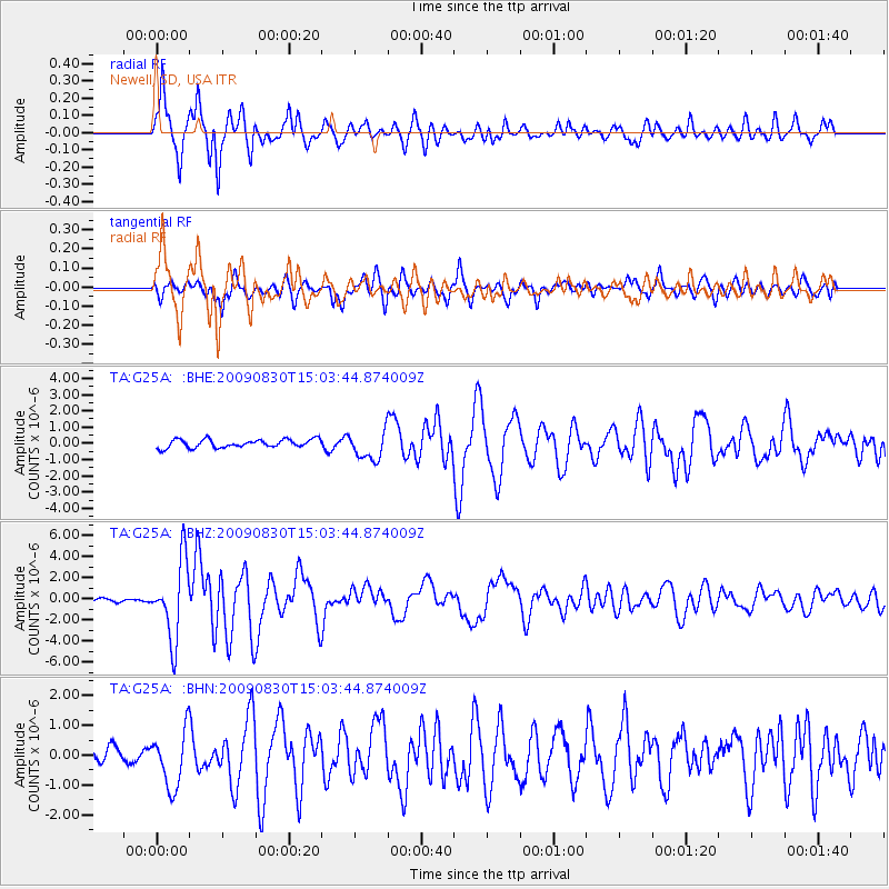
Signal To Noise
| Channel | StoN | STA | LTA |
| TA:G25A: :BHZ:20090830T15:03:44.874009Z | 28.378534 | 3.645372E-6 | 1.2845527E-7 |
| TA:G25A: :BHN:20090830T15:03:44.874009Z | 4.159621 | 9.613457E-7 | 2.3111379E-7 |
| TA:G25A: :BHE:20090830T15:03:44.874009Z | 3.4620163 | 8.716169E-7 | 2.517657E-7 |
| Arrivals |
| Ps | 6.3 SECOND |
| PpPs | 21 SECOND |
| PsPs/PpSs | 28 SECOND |


