You are here: Home > Network List > TA - USArray Transportable Network (new EarthScope stations) Stations List
> Station G25A Newell, SD, USA > Earthquake Result Viewer
G25A Newell, SD, USA - Earthquake Result Viewer
| Earthquake location: |
Near Coast Of Venezuela |
| Earthquake latitude/longitude: |
10.7/-67.9 |
| Earthquake time(UTC): |
2009/09/12 (255) 20:06:24 GMT |
| Earthquake Depth: |
10 km |
| Earthquake Magnitude: |
6.3 MB, 6.4 MS, 6.3 MW, 6.3 MW |
| Earthquake Catalog/Contributor: |
WHDF/NEIC |
|
| Network: |
TA USArray Transportable Network (new EarthScope stations) |
| Station: |
G25A Newell, SD, USA |
| Lat/Lon: |
45.19 N/103.42 W |
| Elevation: |
894 m |
|
| Distance: |
45.9 deg |
| Az: |
325.108 deg |
| Baz: |
127.336 deg |
| Ray Param: |
0.07099612 |
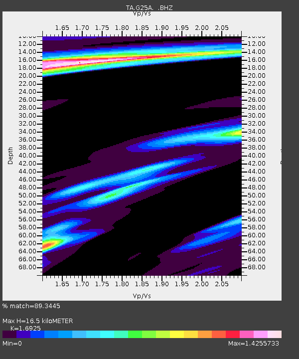
| Estimated Moho Depth: |
16.5 km |
| Estimated Crust Vp/Vs: |
1.69 |
| Assumed Crust Vp: |
6.242 km/s |
| Estimated Crust Vs: |
3.688 km/s |
| Estimated Crust Poisson's Ratio: |
0.23 |
|
| Radial Match: |
89.3445 % |
| Radial Bump: |
357 |
| Transverse Match: |
75.46666 % |
| Transverse Bump: |
400 |
| SOD ConfigId: |
2622 |
| Insert Time: |
2010-03-07 06:08:15.495 +0000 |
| GWidth: |
2.5 |
| Max Bumps: |
400 |
| Tol: |
0.001 |
|

Signal To Noise
| Channel | StoN | STA | LTA |
| TA:G25A: :BHZ:20090912T20:14:16.12401Z | 15.722604 | 1.9942802E-6 | 1.268416E-7 |
| TA:G25A: :BHN:20090912T20:14:16.12401Z | 1.9804497 | 5.7501074E-7 | 2.903435E-7 |
| TA:G25A: :BHE:20090912T20:14:16.12401Z | 0.92447346 | 3.344246E-7 | 3.6174603E-7 |
| Arrivals |
| Ps | 1.9 SECOND |
| PpPs | 6.7 SECOND |
| PsPs/PpSs | 8.6 SECOND |


