You are here: Home > Network List > TA - USArray Transportable Network (new EarthScope stations) Stations List
> Station G25A Newell, SD, USA > Earthquake Result Viewer
G25A Newell, SD, USA - Earthquake Result Viewer

| Earthquake location: |
Samoa Islands Region |
| Earthquake latitude/longitude: |
-15.5/-172.1 |
| Earthquake time(UTC): |
2009/09/29 (272) 17:48:10 GMT |
| Earthquake Depth: |
18 km |
| Earthquake Magnitude: |
7.1 MB, 8.1 MS, 8.1 MW, 8.0 MW |
| Earthquake Catalog/Contributor: |
WHDF/NEIC |
|
| Network: |
TA USArray Transportable Network (new EarthScope stations) |
| Station: |
G25A Newell, SD, USA |
| Lat/Lon: |
45.19 N/103.42 W |
| Elevation: |
894 m |
|
| Distance: |
86.5 deg |
| Az: |
41.292 deg |
| Baz: |
244.129 deg |
| Ray Param: |
0.04395915 |
| Estimated Moho Depth: |
47.75 km |
| Estimated Crust Vp/Vs: |
1.62 |
| Assumed Crust Vp: |
6.242 km/s |
| Estimated Crust Vs: |
3.865 km/s |
| Estimated Crust Poisson's Ratio: |
0.19 |
|
| Radial Match: |
98.03011 % |
| Radial Bump: |
381 |
| Transverse Match: |
94.01206 % |
| Transverse Bump: |
400 |
| SOD ConfigId: |
2622 |
| Insert Time: |
2010-03-07 06:08:17.406 +0000 |
| GWidth: |
2.5 |
| Max Bumps: |
400 |
| Tol: |
0.001 |
|
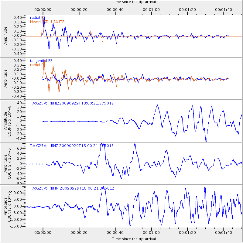
Signal To Noise
| Channel | StoN | STA | LTA |
| TA:G25A: :BHZ:20090929T18:00:21.37501Z | 11.935687 | 2.8137224E-6 | 2.357403E-7 |
| TA:G25A: :BHN:20090929T18:00:21.37501Z | 1.7010267 | 5.8641393E-7 | 3.4474118E-7 |
| TA:G25A: :BHE:20090929T18:00:21.37501Z | 3.647265 | 1.2191136E-6 | 3.342542E-7 |
| Arrivals |
| Ps | 4.8 SECOND |
| PpPs | 20 SECOND |
| PsPs/PpSs | 24 SECOND |


