You are here: Home > Network List > TA - USArray Transportable Network (new EarthScope stations) Stations List
> Station H31M Peel River, Yukon, CAN > Earthquake Result Viewer
H31M Peel River, Yukon, CAN - Earthquake Result Viewer
| Earthquake location: |
Laos |
| Earthquake latitude/longitude: |
19.5/101.3 |
| Earthquake time(UTC): |
2019/11/20 (324) 23:50:44 GMT |
| Earthquake Depth: |
10 km |
| Earthquake Magnitude: |
6.1 Mww |
| Earthquake Catalog/Contributor: |
NEIC PDE/us |
|
| Network: |
TA USArray Transportable Network (new EarthScope stations) |
| Station: |
H31M Peel River, Yukon, CAN |
| Lat/Lon: |
65.81 N/134.34 W |
| Elevation: |
642 m |
|
| Distance: |
85.3 deg |
| Az: |
19.973 deg |
| Baz: |
308.55 deg |
| Ray Param: |
0.044881444 |
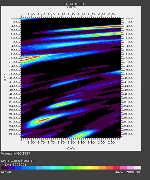
| Estimated Moho Depth: |
30.5 km |
| Estimated Crust Vp/Vs: |
1.60 |
| Assumed Crust Vp: |
6.419 km/s |
| Estimated Crust Vs: |
4.006 km/s |
| Estimated Crust Poisson's Ratio: |
0.18 |
|
| Radial Match: |
80.2387 % |
| Radial Bump: |
400 |
| Transverse Match: |
69.78718 % |
| Transverse Bump: |
400 |
| SOD ConfigId: |
19951751 |
| Insert Time: |
2019-12-05 00:01:11.655 +0000 |
| GWidth: |
2.5 |
| Max Bumps: |
400 |
| Tol: |
0.001 |
|
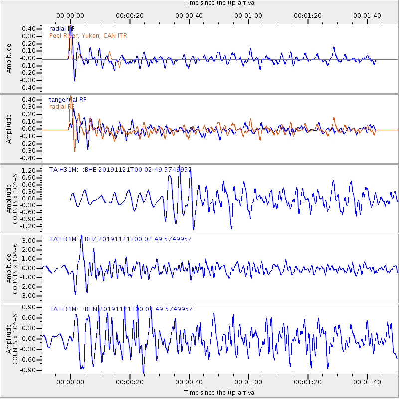
Signal To Noise
| Channel | StoN | STA | LTA |
| TA:H31M: :BHZ:20191121T00:02:49.574995Z | 7.7756824 | 1.6016076E-6 | 2.0597646E-7 |
| TA:H31M: :BHN:20191121T00:02:49.574995Z | 3.5974574 | 5.1035386E-7 | 1.4186516E-7 |
| TA:H31M: :BHE:20191121T00:02:49.574995Z | 2.6876736 | 5.561908E-7 | 2.0694135E-7 |
| Arrivals |
| Ps | 2.9 SECOND |
| PpPs | 12 SECOND |
| PsPs/PpSs | 15 SECOND |


