You are here: Home > Network List > TJ - Tajikistan National Seismic Network Stations List
> Station GARM Garm, Tajikistan > Earthquake Result Viewer
GARM Garm, Tajikistan - Earthquake Result Viewer
| Earthquake location: |
Laos |
| Earthquake latitude/longitude: |
19.5/101.3 |
| Earthquake time(UTC): |
2019/11/20 (324) 23:50:44 GMT |
| Earthquake Depth: |
10 km |
| Earthquake Magnitude: |
6.1 Mww |
| Earthquake Catalog/Contributor: |
NEIC PDE/us |
|
| Network: |
TJ Tajikistan National Seismic Network |
| Station: |
GARM Garm, Tajikistan |
| Lat/Lon: |
39.00 N/70.32 E |
| Elevation: |
1305 m |
|
| Distance: |
33.1 deg |
| Az: |
312.682 deg |
| Baz: |
117.096 deg |
| Ray Param: |
0.078354776 |
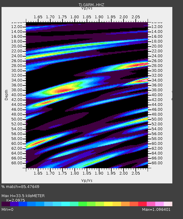
| Estimated Moho Depth: |
33.5 km |
| Estimated Crust Vp/Vs: |
2.10 |
| Assumed Crust Vp: |
6.306 km/s |
| Estimated Crust Vs: |
3.006 km/s |
| Estimated Crust Poisson's Ratio: |
0.35 |
|
| Radial Match: |
85.47649 % |
| Radial Bump: |
396 |
| Transverse Match: |
75.151695 % |
| Transverse Bump: |
361 |
| SOD ConfigId: |
19951751 |
| Insert Time: |
2019-12-05 00:01:44.937 +0000 |
| GWidth: |
2.5 |
| Max Bumps: |
400 |
| Tol: |
0.001 |
|
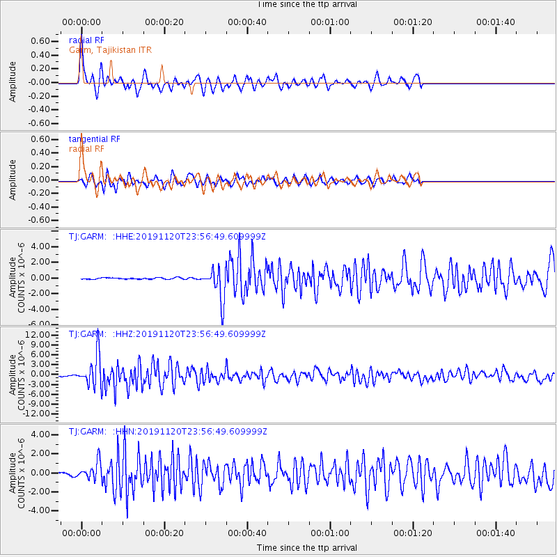
Signal To Noise
| Channel | StoN | STA | LTA |
| TJ:GARM: :HHZ:20191120T23:56:49.609999Z | 28.936226 | 4.7921612E-6 | 1.6561114E-7 |
| TJ:GARM: :HHN:20191120T23:56:49.609999Z | 6.6727905 | 9.3472454E-7 | 1.4008E-7 |
| TJ:GARM: :HHE:20191120T23:56:49.609999Z | 23.400978 | 2.1172646E-6 | 9.0477606E-8 |
| Arrivals |
| Ps | 6.2 SECOND |
| PpPs | 15 SECOND |
| PsPs/PpSs | 22 SECOND |


