You are here: Home > Network List > TS - TERRAscope (Southern California Seismic Network) Stations List
> Station PAS Pasadena, California, USA > Earthquake Result Viewer
PAS Pasadena, California, USA - Earthquake Result Viewer
| Earthquake location: |
Solomon Islands |
| Earthquake latitude/longitude: |
-6.5/154.9 |
| Earthquake time(UTC): |
1994/04/18 (108) 17:29:56 GMT |
| Earthquake Depth: |
43 km |
| Earthquake Magnitude: |
6.6 MB, 6.7 MS, 6.8 UNKNOWN, 6.7 MW |
| Earthquake Catalog/Contributor: |
WHDF/NEIC |
|
| Network: |
TS TERRAscope (Southern California Seismic Network) |
| Station: |
PAS Pasadena, California, USA |
| Lat/Lon: |
34.15 N/118.17 W |
| Elevation: |
295 m |
|
| Distance: |
91.0 deg |
| Az: |
55.921 deg |
| Baz: |
262.936 deg |
| Ray Param: |
0.041623645 |
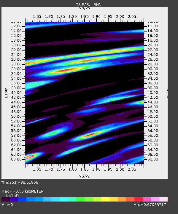
| Estimated Moho Depth: |
67.0 km |
| Estimated Crust Vp/Vs: |
1.61 |
| Assumed Crust Vp: |
6.1 km/s |
| Estimated Crust Vs: |
3.789 km/s |
| Estimated Crust Poisson's Ratio: |
0.19 |
|
| Radial Match: |
88.51808 % |
| Radial Bump: |
400 |
| Transverse Match: |
83.05481 % |
| Transverse Bump: |
400 |
| SOD ConfigId: |
16938 |
| Insert Time: |
2010-02-26 14:35:40.213 +0000 |
| GWidth: |
2.5 |
| Max Bumps: |
400 |
| Tol: |
0.001 |
|
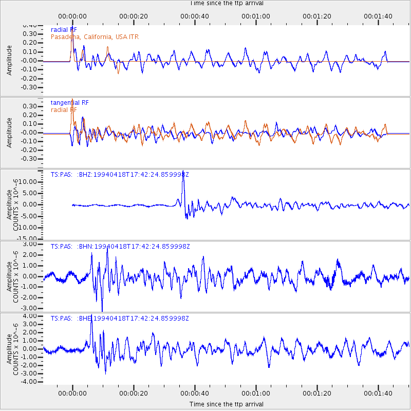
Signal To Noise
| Channel | StoN | STA | LTA |
| TS:PAS: :BHN:19940418T17:42:24.859998Z | 1.3883936 | 3.1941292E-7 | 2.3005933E-7 |
| TS:PAS: :BHE:19940418T17:42:24.859998Z | 1.3175259 | 3.2778343E-7 | 2.4878707E-7 |
| TS:PAS: :BHZ:19940418T17:42:24.859998Z | 3.7190588 | 9.3495976E-7 | 2.513969E-7 |
| Arrivals |
| Ps | 6.8 SECOND |
| PpPs | 28 SECOND |
| PsPs/PpSs | 35 SECOND |


