You are here: Home > Network List > TA - USArray Transportable Network (new EarthScope stations) Stations List
> Station C16K Lisburne Hills, AK, USA > Earthquake Result Viewer
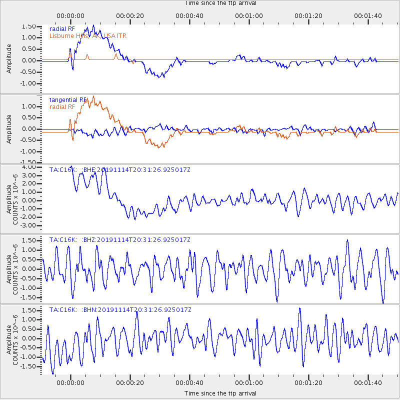
C16K Lisburne Hills, AK, USA - Earthquake Result Viewer
*The percent match for this event was below the threshold and hence no stack was calculated.
| Earthquake location: |
Northern Molucca Sea |
| Earthquake latitude/longitude: |
1.8/126.3 |
| Earthquake time(UTC): |
2019/11/14 (318) 20:19:47 GMT |
| Earthquake Depth: |
15 km |
| Earthquake Magnitude: |
5.5 mb |
| Earthquake Catalog/Contributor: |
NEIC PDE/us |
|
| Network: |
TA USArray Transportable Network (new EarthScope stations) |
| Station: |
C16K Lisburne Hills, AK, USA |
| Lat/Lon: |
68.27 N/165.34 W |
| Elevation: |
102 m |
|
| Distance: |
80.5 deg |
| Az: |
20.548 deg |
| Baz: |
250.442 deg |
| Ray Param: |
$rayparam |
*The percent match for this event was below the threshold and hence was not used in the summary stack. |
|
| Radial Match: |
42.48149 % |
| Radial Bump: |
400 |
| Transverse Match: |
42.95069 % |
| Transverse Bump: |
400 |
| SOD ConfigId: |
19951751 |
| Insert Time: |
2019-12-06 00:52:07.753 +0000 |
| GWidth: |
2.5 |
| Max Bumps: |
400 |
| Tol: |
0.001 |
|
Signal To Noise
| Channel | StoN | STA | LTA |
| TA:C16K: :BHZ:20191114T20:31:26.925017Z | 1.491474 | 8.071698E-7 | 5.411893E-7 |
| TA:C16K: :BHN:20191114T20:31:26.925017Z | 1.2327788 | 1.3413857E-6 | 1.0880992E-6 |
| TA:C16K: :BHE:20191114T20:31:26.925017Z | 1.0308666 | 1.9219856E-6 | 1.8644369E-6 |
| Arrivals |
| Ps | |
| PpPs | |
| PsPs/PpSs | |


