You are here: Home > Network List > TS - TERRAscope (Southern California Seismic Network) Stations List
> Station PAS Pasadena, California, USA > Earthquake Result Viewer
PAS Pasadena, California, USA - Earthquake Result Viewer

| Earthquake location: |
Northern Colombia |
| Earthquake latitude/longitude: |
7.4/-72.1 |
| Earthquake time(UTC): |
1994/05/31 (151) 17:41:55 GMT |
| Earthquake Depth: |
13 km |
| Earthquake Magnitude: |
6.3 MB, 5.6 MS, 6.0 UNKNOWN, 6.0 MW |
| Earthquake Catalog/Contributor: |
WHDF/NEIC |
|
| Network: |
TS TERRAscope (Southern California Seismic Network) |
| Station: |
PAS Pasadena, California, USA |
| Lat/Lon: |
34.15 N/118.17 W |
| Elevation: |
295 m |
|
| Distance: |
50.1 deg |
| Az: |
308.78 deg |
| Baz: |
111.223 deg |
| Ray Param: |
0.06829768 |
| Estimated Moho Depth: |
22.75 km |
| Estimated Crust Vp/Vs: |
1.80 |
| Assumed Crust Vp: |
6.1 km/s |
| Estimated Crust Vs: |
3.384 km/s |
| Estimated Crust Poisson's Ratio: |
0.28 |
|
| Radial Match: |
89.09694 % |
| Radial Bump: |
376 |
| Transverse Match: |
88.25723 % |
| Transverse Bump: |
373 |
| SOD ConfigId: |
16938 |
| Insert Time: |
2010-02-26 14:35:42.484 +0000 |
| GWidth: |
2.5 |
| Max Bumps: |
400 |
| Tol: |
0.001 |
|
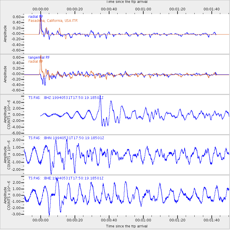
Signal To Noise
| Channel | StoN | STA | LTA |
| TS:PAS: :BHN:19940531T17:50:19.18501Z | 1.551712 | 8.9502885E-7 | 5.7680086E-7 |
| TS:PAS: :BHE:19940531T17:50:19.18501Z | 2.3240843 | 1.1367896E-6 | 4.8913444E-7 |
| TS:PAS: :BHZ:19940531T17:50:19.18501Z | 3.6525931 | 1.956236E-6 | 5.355746E-7 |
| Arrivals |
| Ps | 3.1 SECOND |
| PpPs | 9.9 SECOND |
| PsPs/PpSs | 13 SECOND |


