You are here: Home > Network List > GO - National Seismic Network of Georgia Stations List
> Station TBLG Delisi, Georgia > Earthquake Result Viewer
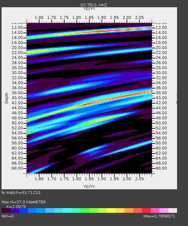
TBLG Delisi, Georgia - Earthquake Result Viewer
| Earthquake location: |
Irian Jaya Region, Indonesia |
| Earthquake latitude/longitude: |
1.6/132.8 |
| Earthquake time(UTC): |
2019/11/23 (327) 12:11:16 GMT |
| Earthquake Depth: |
10 km |
| Earthquake Magnitude: |
6.1 Mww |
| Earthquake Catalog/Contributor: |
NEIC PDE/us |
|
| Network: |
GO National Seismic Network of Georgia |
| Station: |
TBLG Delisi, Georgia |
| Lat/Lon: |
41.73 N/44.74 E |
| Elevation: |
510 m |
|
| Distance: |
87.5 deg |
| Az: |
311.514 deg |
| Baz: |
90.084 deg |
| Ray Param: |
0.043306008 |
| Estimated Moho Depth: |
37.0 km |
| Estimated Crust Vp/Vs: |
2.10 |
| Assumed Crust Vp: |
6.291 km/s |
| Estimated Crust Vs: |
2.999 km/s |
| Estimated Crust Poisson's Ratio: |
0.35 |
|
| Radial Match: |
83.71233 % |
| Radial Bump: |
400 |
| Transverse Match: |
78.16869 % |
| Transverse Bump: |
400 |
| SOD ConfigId: |
19951751 |
| Insert Time: |
2019-12-07 12:19:03.183 +0000 |
| GWidth: |
2.5 |
| Max Bumps: |
400 |
| Tol: |
0.001 |
|

Signal To Noise
| Channel | StoN | STA | LTA |
| GO:TBLG: :HHZ:20191123T12:23:32.349989Z | 10.690024 | 1.321276E-6 | 1.2359898E-7 |
| GO:TBLG: :HHN:20191123T12:23:32.349989Z | 4.549859 | 3.0367872E-7 | 6.674464E-8 |
| GO:TBLG: :HHE:20191123T12:23:32.349989Z | 4.578551 | 3.935469E-7 | 8.595447E-8 |
| Arrivals |
| Ps | 6.6 SECOND |
| PpPs | 18 SECOND |
| PsPs/PpSs | 24 SECOND |


