You are here: Home > Network List > TA - USArray Transportable Network (new EarthScope stations) Stations List
> Station A22K Sinclair Lake, AK, USA > Earthquake Result Viewer
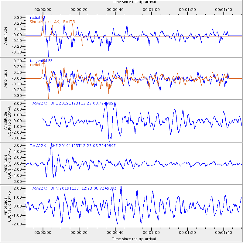
A22K Sinclair Lake, AK, USA - Earthquake Result Viewer
| Earthquake location: |
Irian Jaya Region, Indonesia |
| Earthquake latitude/longitude: |
1.6/132.8 |
| Earthquake time(UTC): |
2019/11/23 (327) 12:11:16 GMT |
| Earthquake Depth: |
10 km |
| Earthquake Magnitude: |
6.1 Mww |
| Earthquake Catalog/Contributor: |
NEIC PDE/us |
|
| Network: |
TA USArray Transportable Network (new EarthScope stations) |
| Station: |
A22K Sinclair Lake, AK, USA |
| Lat/Lon: |
71.00 N/154.97 W |
| Elevation: |
6.0 m |
|
| Distance: |
82.7 deg |
| Az: |
18.324 deg |
| Baz: |
253.674 deg |
| Ray Param: |
0.046683505 |
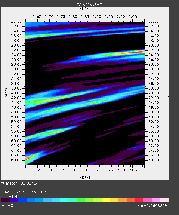
| Estimated Moho Depth: |
67.25 km |
| Estimated Crust Vp/Vs: |
1.60 |
| Assumed Crust Vp: |
5.782 km/s |
| Estimated Crust Vs: |
3.614 km/s |
| Estimated Crust Poisson's Ratio: |
0.18 |
|
| Radial Match: |
82.31484 % |
| Radial Bump: |
345 |
| Transverse Match: |
69.99077 % |
| Transverse Bump: |
400 |
| SOD ConfigId: |
19951751 |
| Insert Time: |
2019-12-07 12:20:34.422 +0000 |
| GWidth: |
2.5 |
| Max Bumps: |
400 |
| Tol: |
0.001 |
|
Signal To Noise
| Channel | StoN | STA | LTA |
| TA:A22K: :BHZ:20191123T12:23:08.724989Z | 10.491667 | 2.7585534E-6 | 2.6292804E-7 |
| TA:A22K: :BHN:20191123T12:23:08.724989Z | 0.5434083 | 4.3046808E-7 | 7.921633E-7 |
| TA:A22K: :BHE:20191123T12:23:08.724989Z | 2.453308 | 1.2912443E-6 | 5.263278E-7 |
| Arrivals |
| Ps | 7.1 SECOND |
| PpPs | 30 SECOND |
| PsPs/PpSs | 37 SECOND |


