You are here: Home > Network List > TA - USArray Transportable Network (new EarthScope stations) Stations List
> Station B18K Kokolik River, AK, USA > Earthquake Result Viewer
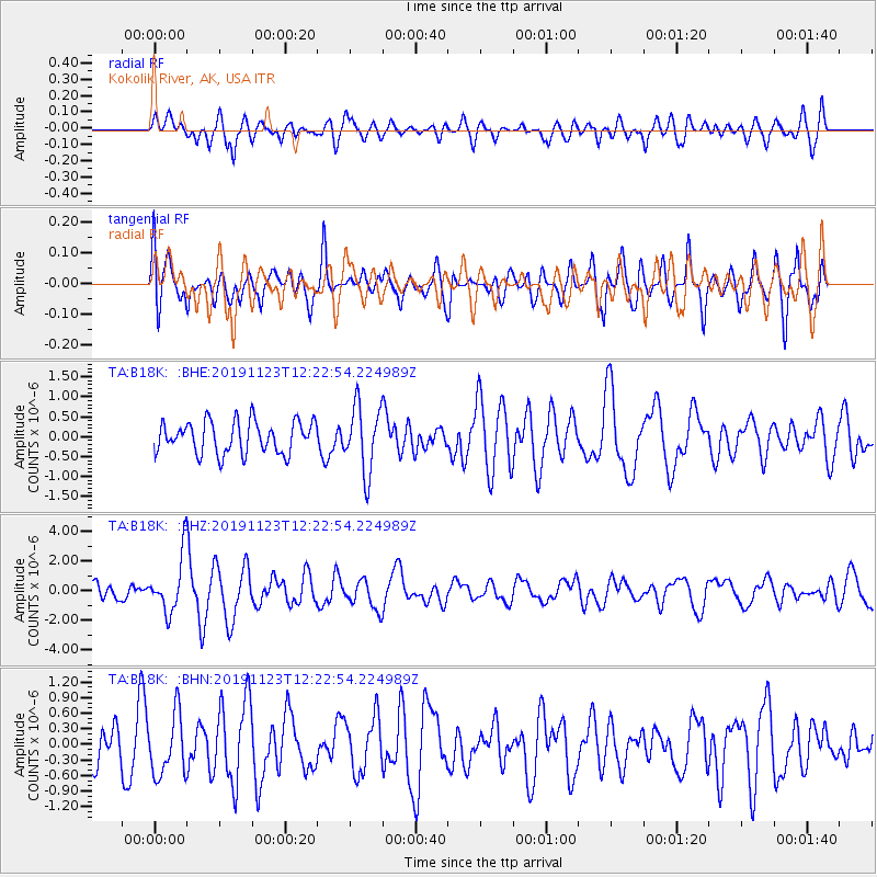
B18K Kokolik River, AK, USA - Earthquake Result Viewer
*The percent match for this event was below the threshold and hence no stack was calculated.
| Earthquake location: |
Irian Jaya Region, Indonesia |
| Earthquake latitude/longitude: |
1.6/132.8 |
| Earthquake time(UTC): |
2019/11/23 (327) 12:11:16 GMT |
| Earthquake Depth: |
10 km |
| Earthquake Magnitude: |
6.1 Mww |
| Earthquake Catalog/Contributor: |
NEIC PDE/us |
|
| Network: |
TA USArray Transportable Network (new EarthScope stations) |
| Station: |
B18K Kokolik River, AK, USA |
| Lat/Lon: |
69.36 N/161.80 W |
| Elevation: |
222 m |
|
| Distance: |
80.0 deg |
| Az: |
19.108 deg |
| Baz: |
247.372 deg |
| Ray Param: |
$rayparam |
*The percent match for this event was below the threshold and hence was not used in the summary stack. |
|
| Radial Match: |
57.467155 % |
| Radial Bump: |
400 |
| Transverse Match: |
57.39076 % |
| Transverse Bump: |
400 |
| SOD ConfigId: |
19951751 |
| Insert Time: |
2019-12-07 12:20:35.389 +0000 |
| GWidth: |
2.5 |
| Max Bumps: |
400 |
| Tol: |
0.001 |
|
Signal To Noise
| Channel | StoN | STA | LTA |
| TA:B18K: :BHZ:20191123T12:22:54.224989Z | 2.775893 | 1.8945947E-6 | 6.825172E-7 |
| TA:B18K: :BHN:20191123T12:22:54.224989Z | 1.1950727 | 5.8652614E-7 | 4.9078704E-7 |
| TA:B18K: :BHE:20191123T12:22:54.224989Z | 2.0794435 | 8.320243E-7 | 4.0011872E-7 |
| Arrivals |
| Ps | |
| PpPs | |
| PsPs/PpSs | |


