You are here: Home > Network List > TA - USArray Transportable Network (new EarthScope stations) Stations List
> Station D23K Nanushuk River, AK USA > Earthquake Result Viewer
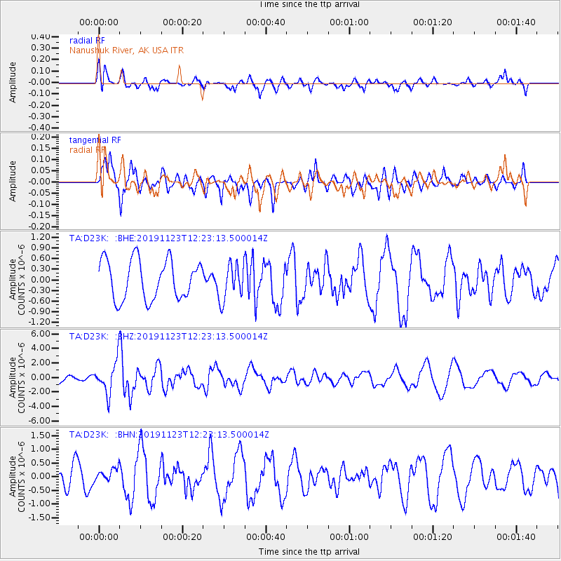
D23K Nanushuk River, AK USA - Earthquake Result Viewer
*The percent match for this event was below the threshold and hence no stack was calculated.
| Earthquake location: |
Irian Jaya Region, Indonesia |
| Earthquake latitude/longitude: |
1.6/132.8 |
| Earthquake time(UTC): |
2019/11/23 (327) 12:11:16 GMT |
| Earthquake Depth: |
10 km |
| Earthquake Magnitude: |
6.1 Mww |
| Earthquake Catalog/Contributor: |
NEIC PDE/us |
|
| Network: |
TA USArray Transportable Network (new EarthScope stations) |
| Station: |
D23K Nanushuk River, AK USA |
| Lat/Lon: |
68.97 N/150.68 W |
| Elevation: |
406 m |
|
| Distance: |
83.7 deg |
| Az: |
20.687 deg |
| Baz: |
257.986 deg |
| Ray Param: |
$rayparam |
*The percent match for this event was below the threshold and hence was not used in the summary stack. |
|
| Radial Match: |
53.361145 % |
| Radial Bump: |
372 |
| Transverse Match: |
76.5146 % |
| Transverse Bump: |
400 |
| SOD ConfigId: |
19951751 |
| Insert Time: |
2019-12-07 12:20:44.850 +0000 |
| GWidth: |
2.5 |
| Max Bumps: |
400 |
| Tol: |
0.001 |
|
Signal To Noise
| Channel | StoN | STA | LTA |
| TA:D23K: :BHZ:20191123T12:23:13.500014Z | 2.9800298 | 2.350547E-6 | 7.887663E-7 |
| TA:D23K: :BHN:20191123T12:23:13.500014Z | 0.6183299 | 2.3455131E-7 | 3.7933037E-7 |
| TA:D23K: :BHE:20191123T12:23:13.500014Z | 0.9213378 | 5.0864844E-7 | 5.5207596E-7 |
| Arrivals |
| Ps | |
| PpPs | |
| PsPs/PpSs | |


