You are here: Home > Network List > TA - USArray Transportable Network (new EarthScope stations) Stations List
> Station E19K Redstone River, AK, USA > Earthquake Result Viewer
E19K Redstone River, AK, USA - Earthquake Result Viewer
| Earthquake location: |
Irian Jaya Region, Indonesia |
| Earthquake latitude/longitude: |
1.6/132.8 |
| Earthquake time(UTC): |
2019/11/23 (327) 12:11:16 GMT |
| Earthquake Depth: |
10 km |
| Earthquake Magnitude: |
6.1 Mww |
| Earthquake Catalog/Contributor: |
NEIC PDE/us |
|
| Network: |
TA USArray Transportable Network (new EarthScope stations) |
| Station: |
E19K Redstone River, AK, USA |
| Lat/Lon: |
67.46 N/157.23 W |
| Elevation: |
441 m |
|
| Distance: |
80.9 deg |
| Az: |
21.524 deg |
| Baz: |
252.019 deg |
| Ray Param: |
0.0479562 |
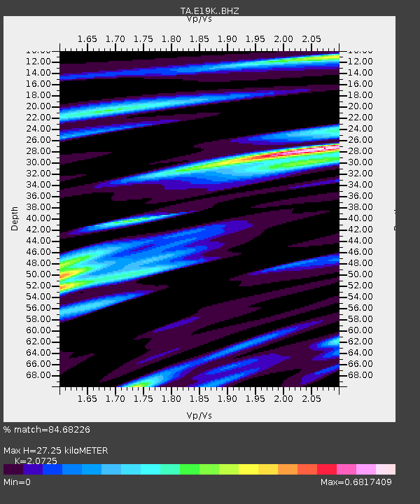
| Estimated Moho Depth: |
27.25 km |
| Estimated Crust Vp/Vs: |
2.07 |
| Assumed Crust Vp: |
6.577 km/s |
| Estimated Crust Vs: |
3.173 km/s |
| Estimated Crust Poisson's Ratio: |
0.35 |
|
| Radial Match: |
84.68226 % |
| Radial Bump: |
400 |
| Transverse Match: |
78.75581 % |
| Transverse Bump: |
400 |
| SOD ConfigId: |
19951751 |
| Insert Time: |
2019-12-07 12:20:48.011 +0000 |
| GWidth: |
2.5 |
| Max Bumps: |
400 |
| Tol: |
0.001 |
|

Signal To Noise
| Channel | StoN | STA | LTA |
| TA:E19K: :BHZ:20191123T12:22:59.149977Z | 8.598745 | 1.762101E-6 | 2.0492536E-7 |
| TA:E19K: :BHN:20191123T12:22:59.149977Z | 1.5630367 | 2.308827E-7 | 1.477142E-7 |
| TA:E19K: :BHE:20191123T12:22:59.149977Z | 3.0320687 | 6.97295E-7 | 2.2997334E-7 |
| Arrivals |
| Ps | 4.6 SECOND |
| PpPs | 12 SECOND |
| PsPs/PpSs | 17 SECOND |


