You are here: Home > Network List > TA - USArray Transportable Network (new EarthScope stations) Stations List
> Station E23K Chandalar, AK, USA > Earthquake Result Viewer
E23K Chandalar, AK, USA - Earthquake Result Viewer
| Earthquake location: |
Irian Jaya Region, Indonesia |
| Earthquake latitude/longitude: |
1.6/132.8 |
| Earthquake time(UTC): |
2019/11/23 (327) 12:11:16 GMT |
| Earthquake Depth: |
10 km |
| Earthquake Magnitude: |
6.1 Mww |
| Earthquake Catalog/Contributor: |
NEIC PDE/us |
|
| Network: |
TA USArray Transportable Network (new EarthScope stations) |
| Station: |
E23K Chandalar, AK, USA |
| Lat/Lon: |
68.06 N/149.62 W |
| Elevation: |
1084 m |
|
| Distance: |
83.9 deg |
| Az: |
21.664 deg |
| Baz: |
259.081 deg |
| Ray Param: |
0.0458828 |
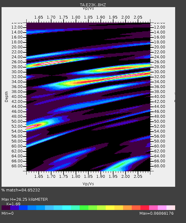
| Estimated Moho Depth: |
26.25 km |
| Estimated Crust Vp/Vs: |
1.69 |
| Assumed Crust Vp: |
6.316 km/s |
| Estimated Crust Vs: |
3.737 km/s |
| Estimated Crust Poisson's Ratio: |
0.23 |
|
| Radial Match: |
84.65232 % |
| Radial Bump: |
400 |
| Transverse Match: |
72.95405 % |
| Transverse Bump: |
400 |
| SOD ConfigId: |
19951751 |
| Insert Time: |
2019-12-07 12:20:51.063 +0000 |
| GWidth: |
2.5 |
| Max Bumps: |
400 |
| Tol: |
0.001 |
|

Signal To Noise
| Channel | StoN | STA | LTA |
| TA:E23K: :BHZ:20191123T12:23:14.550001Z | 7.7571898 | 1.8232439E-6 | 2.3503922E-7 |
| TA:E23K: :BHN:20191123T12:23:14.550001Z | 1.4212885 | 2.7706827E-7 | 1.949416E-7 |
| TA:E23K: :BHE:20191123T12:23:14.550001Z | 1.9686214 | 4.228785E-7 | 2.1480945E-7 |
| Arrivals |
| Ps | 2.9 SECOND |
| PpPs | 11 SECOND |
| PsPs/PpSs | 14 SECOND |


