You are here: Home > Network List > TS - TERRAscope (Southern California Seismic Network) Stations List
> Station PAS Pasadena, California, USA > Earthquake Result Viewer
PAS Pasadena, California, USA - Earthquake Result Viewer
| Earthquake location: |
Peru-Bolivia Border Region |
| Earthquake latitude/longitude: |
-17.5/-69.7 |
| Earthquake time(UTC): |
1994/12/12 (346) 07:41:55 GMT |
| Earthquake Depth: |
151 km |
| Earthquake Magnitude: |
5.8 MB, 6.1 UNKNOWN, 6.3 MW |
| Earthquake Catalog/Contributor: |
WHDF/NEIC |
|
| Network: |
TS TERRAscope (Southern California Seismic Network) |
| Station: |
PAS Pasadena, California, USA |
| Lat/Lon: |
34.15 N/118.17 W |
| Elevation: |
295 m |
|
| Distance: |
69.1 deg |
| Az: |
318.301 deg |
| Baz: |
130.055 deg |
| Ray Param: |
0.055474885 |
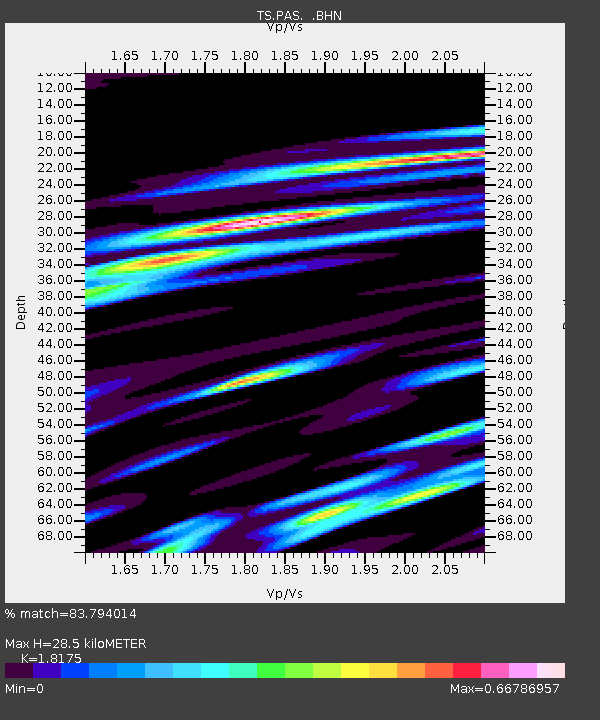
| Estimated Moho Depth: |
28.5 km |
| Estimated Crust Vp/Vs: |
1.82 |
| Assumed Crust Vp: |
6.1 km/s |
| Estimated Crust Vs: |
3.356 km/s |
| Estimated Crust Poisson's Ratio: |
0.28 |
|
| Radial Match: |
83.794014 % |
| Radial Bump: |
313 |
| Transverse Match: |
65.01357 % |
| Transverse Bump: |
400 |
| SOD ConfigId: |
16938 |
| Insert Time: |
2010-02-26 14:35:50.338 +0000 |
| GWidth: |
2.5 |
| Max Bumps: |
400 |
| Tol: |
0.001 |
|
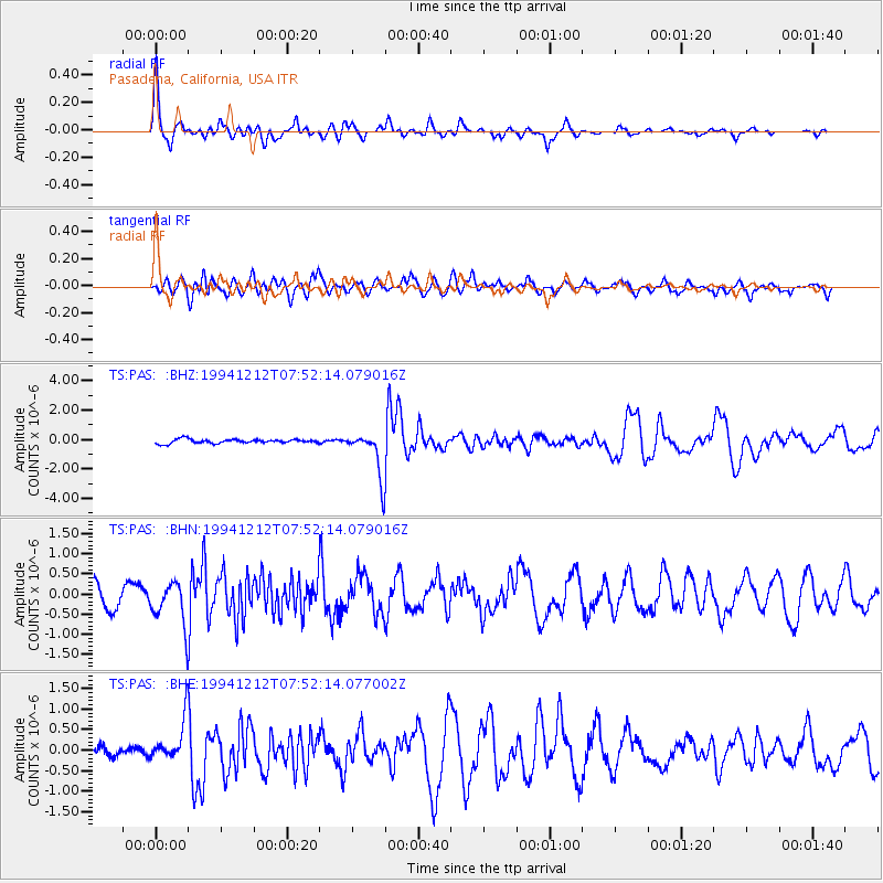
Signal To Noise
| Channel | StoN | STA | LTA |
| TS:PAS: :BHN:19941212T07:52:14.079016Z | 2.3528674 | 5.2205024E-7 | 2.2187832E-7 |
| TS:PAS: :BHE:19941212T07:52:14.077002Z | 3.4711602 | 4.962281E-7 | 1.4295742E-7 |
| TS:PAS: :BHZ:19941212T07:52:14.079016Z | 11.2713995 | 1.5569588E-6 | 1.3813357E-7 |
| Arrivals |
| Ps | 3.9 SECOND |
| PpPs | 13 SECOND |
| PsPs/PpSs | 17 SECOND |


