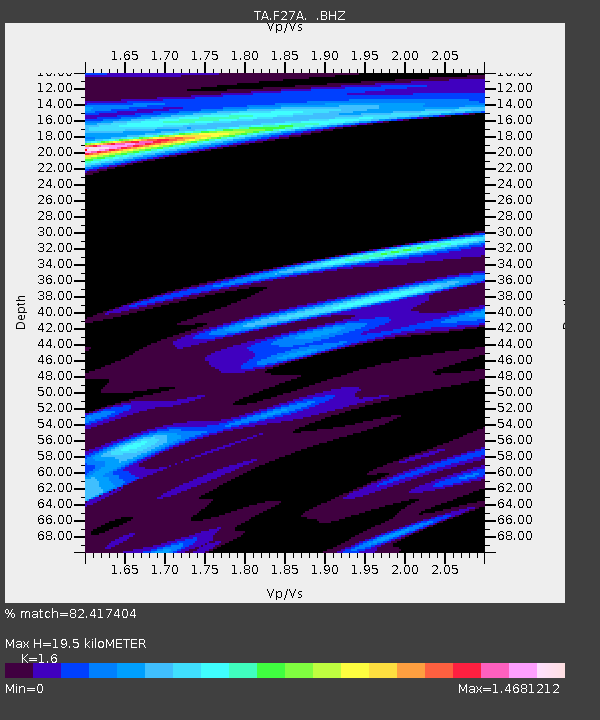
F27A Lemmon, SD, USA - Earthquake Result Viewer

Earthquake location: Fox Islands, Aleutian Islands
Earthquake latitude/longitude: 52.6/-167.1
Earthquake time(UTC): 2009/10/13 (286) 20:21:53 GMT
Earthquake Depth: 14 km
Earthquake Magnitude: 5.9 MB, 6.4 MS, 6.4 MW, 6.4 MW
Earthquake Catalog/Contributor: WHDF/NEIC
Network: TA USArray Transportable Network (new EarthScope stations)
Station: F27A Lemmon, SD, USA
Lat/Lon: 45.87 N/102.02 W
Elevation: 757 m
Distance: 41.7 deg
Az: 72.22 deg
Baz: 303.772 deg
Ray Param: 0.07360296
Estimated Moho Depth: 19.5 km
Estimated Crust Vp/Vs: 1.60
Assumed Crust Vp: 6.242 km/s
Estimated Crust Vs: 3.901 km/s
Estimated Crust Poisson's Ratio: 0.18
Radial Match: 82.417404 %
Radial Bump: 343
Transverse Match: 59.40766 %
Transverse Bump: 400
SOD ConfigId: 2622
Insert Time: 2010-03-07 06:10:37.015 +0000
GWidth: 2.5
Max Bumps: 400
Tol: 0.001

Signal To Noise

ChannelStoNSTALTA
TA:F27A: :BHZ:20091013T20:29:10.700Z2.21083245.6709746E-72.565086E-7
TA:F27A: :BHN:20091013T20:29:10.700Z0.93766719.3445647E-79.96576E-7
TA:F27A: :BHE:20091013T20:29:10.700Z2.75342921.176266E-64.2720038E-7
Arrivals
Ps2.0 SECOND
PpPs7.6 SECOND
PsPs/PpSs9.6 SECOND