You are here: Home > Network List > TA - USArray Transportable Network (new EarthScope stations) Stations List
> Station F27A Lemmon, SD, USA > Earthquake Result Viewer
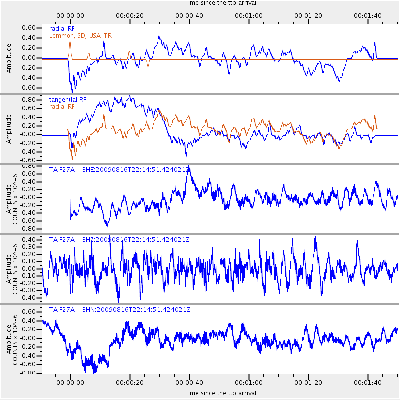
F27A Lemmon, SD, USA - Earthquake Result Viewer
*The percent match for this event was below the threshold and hence no stack was calculated.
| Earthquake location: |
Fiji Islands Region |
| Earthquake latitude/longitude: |
-17.9/-179.4 |
| Earthquake time(UTC): |
2009/08/16 (228) 22:03:09 GMT |
| Earthquake Depth: |
626 km |
| Earthquake Magnitude: |
5.5 MW, 4.9 MB |
| Earthquake Catalog/Contributor: |
WHDF/NEIC |
|
| Network: |
TA USArray Transportable Network (new EarthScope stations) |
| Station: |
F27A Lemmon, SD, USA |
| Lat/Lon: |
45.87 N/102.02 W |
| Elevation: |
757 m |
|
| Distance: |
94.2 deg |
| Az: |
43.128 deg |
| Baz: |
248.674 deg |
| Ray Param: |
$rayparam |
*The percent match for this event was below the threshold and hence was not used in the summary stack. |
|
| Radial Match: |
46.138874 % |
| Radial Bump: |
400 |
| Transverse Match: |
24.789175 % |
| Transverse Bump: |
400 |
| SOD ConfigId: |
2622 |
| Insert Time: |
2010-03-07 06:10:42.766 +0000 |
| GWidth: |
2.5 |
| Max Bumps: |
400 |
| Tol: |
0.001 |
|
Signal To Noise
| Channel | StoN | STA | LTA |
| TA:F27A: :BHZ:20090816T22:14:51.424021Z | 0.845631 | 1.2133718E-7 | 1.4348714E-7 |
| TA:F27A: :BHN:20090816T22:14:51.424021Z | 4.5895042 | 7.034464E-7 | 1.5327286E-7 |
| TA:F27A: :BHE:20090816T22:14:51.424021Z | 1.2874414 | 2.1876532E-7 | 1.6992256E-7 |
| Arrivals |
| Ps | |
| PpPs | |
| PsPs/PpSs | |


