You are here: Home > Network List > TS - TERRAscope (Southern California Seismic Network) Stations List
> Station PAS Pasadena, California, USA > Earthquake Result Viewer
PAS Pasadena, California, USA - Earthquake Result Viewer
| Earthquake location: |
Near Coast Of Central Chile |
| Earthquake latitude/longitude: |
-31.1/-71.6 |
| Earthquake time(UTC): |
1994/09/12 (255) 06:29:56 GMT |
| Earthquake Depth: |
53 km |
| Earthquake Magnitude: |
5.8 MB, 6.0 UNKNOWN, 5.5 MD |
| Earthquake Catalog/Contributor: |
WHDF/NEIC |
|
| Network: |
TS TERRAscope (Southern California Seismic Network) |
| Station: |
PAS Pasadena, California, USA |
| Lat/Lon: |
34.15 N/118.17 W |
| Elevation: |
295 m |
|
| Distance: |
78.4 deg |
| Az: |
322.085 deg |
| Baz: |
140.552 deg |
| Ray Param: |
0.049599595 |
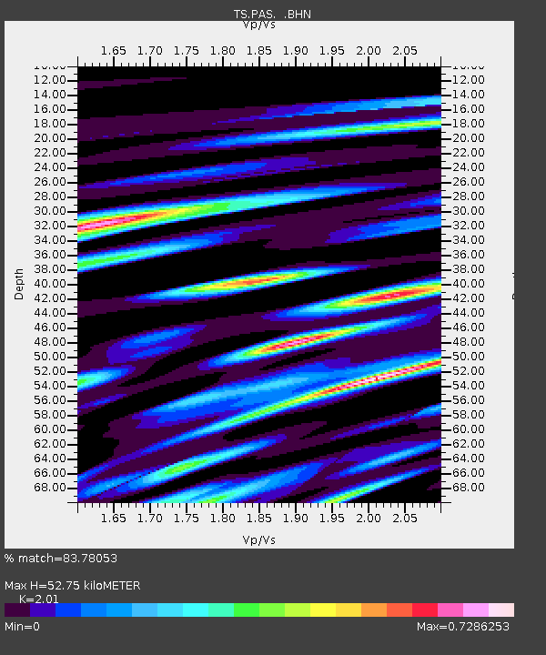
| Estimated Moho Depth: |
52.75 km |
| Estimated Crust Vp/Vs: |
2.01 |
| Assumed Crust Vp: |
6.1 km/s |
| Estimated Crust Vs: |
3.035 km/s |
| Estimated Crust Poisson's Ratio: |
0.34 |
|
| Radial Match: |
83.78053 % |
| Radial Bump: |
351 |
| Transverse Match: |
75.53621 % |
| Transverse Bump: |
400 |
| SOD ConfigId: |
17000 |
| Insert Time: |
2010-02-26 14:35:52.552 +0000 |
| GWidth: |
2.5 |
| Max Bumps: |
400 |
| Tol: |
0.001 |
|
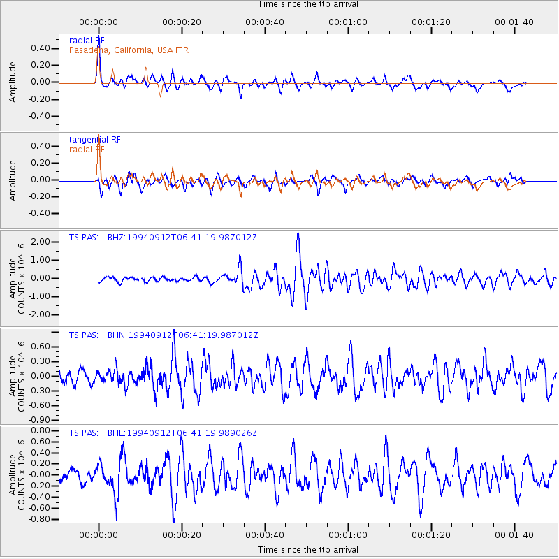
Signal To Noise
| Channel | StoN | STA | LTA |
| TS:PAS: :BHN:19940912T06:41:19.987012Z | 0.81088924 | 1.2407367E-7 | 1.5300938E-7 |
| TS:PAS: :BHE:19940912T06:41:19.989026Z | 2.8090782 | 2.6552223E-7 | 9.452291E-8 |
| TS:PAS: :BHZ:19940912T06:41:19.987012Z | 3.9179902 | 4.3283038E-7 | 1.1047255E-7 |
| Arrivals |
| Ps | 8.9 SECOND |
| PpPs | 25 SECOND |
| PsPs/PpSs | 34 SECOND |


