You are here: Home > Network List > TA - USArray Transportable Network (new EarthScope stations) Stations List
> Station G21K Allakaket, AK, USA > Earthquake Result Viewer
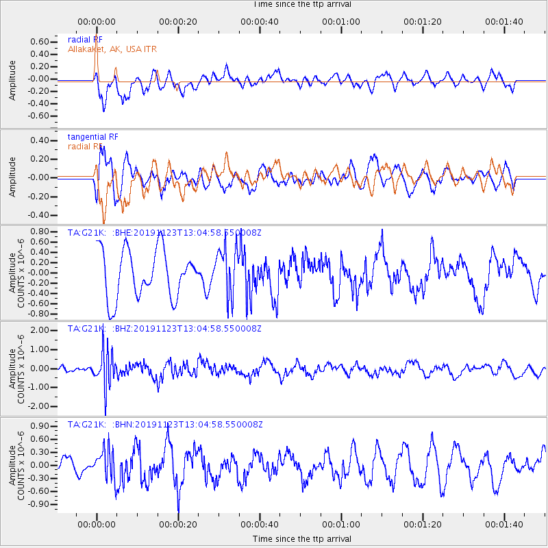
G21K Allakaket, AK, USA - Earthquake Result Viewer
*The percent match for this event was below the threshold and hence no stack was calculated.
| Earthquake location: |
Kuril Islands |
| Earthquake latitude/longitude: |
43.9/147.2 |
| Earthquake time(UTC): |
2019/11/23 (327) 12:58:05 GMT |
| Earthquake Depth: |
6.3 km |
| Earthquake Magnitude: |
5.7 mb |
| Earthquake Catalog/Contributor: |
NEIC PDE/us |
|
| Network: |
TA USArray Transportable Network (new EarthScope stations) |
| Station: |
G21K Allakaket, AK, USA |
| Lat/Lon: |
66.52 N/153.51 W |
| Elevation: |
446 m |
|
| Distance: |
38.7 deg |
| Az: |
33.463 deg |
| Baz: |
264.335 deg |
| Ray Param: |
$rayparam |
*The percent match for this event was below the threshold and hence was not used in the summary stack. |
|
| Radial Match: |
53.59547 % |
| Radial Bump: |
400 |
| Transverse Match: |
65.359695 % |
| Transverse Bump: |
400 |
| SOD ConfigId: |
19951751 |
| Insert Time: |
2019-12-07 13:13:32.784 +0000 |
| GWidth: |
2.5 |
| Max Bumps: |
400 |
| Tol: |
0.001 |
|
Signal To Noise
| Channel | StoN | STA | LTA |
| TA:G21K: :BHZ:20191123T13:04:58.550008Z | 5.5914717 | 9.470789E-7 | 1.6937918E-7 |
| TA:G21K: :BHN:20191123T13:04:58.550008Z | 0.7402808 | 3.490717E-7 | 4.7153958E-7 |
| TA:G21K: :BHE:20191123T13:04:58.550008Z | 1.0045316 | 4.700031E-7 | 4.6788284E-7 |
| Arrivals |
| Ps | |
| PpPs | |
| PsPs/PpSs | |


