You are here: Home > Network List > TA - USArray Transportable Network (new EarthScope stations) Stations List
> Station A26A Wade Farm, Kenmare, ND, USA > Earthquake Result Viewer
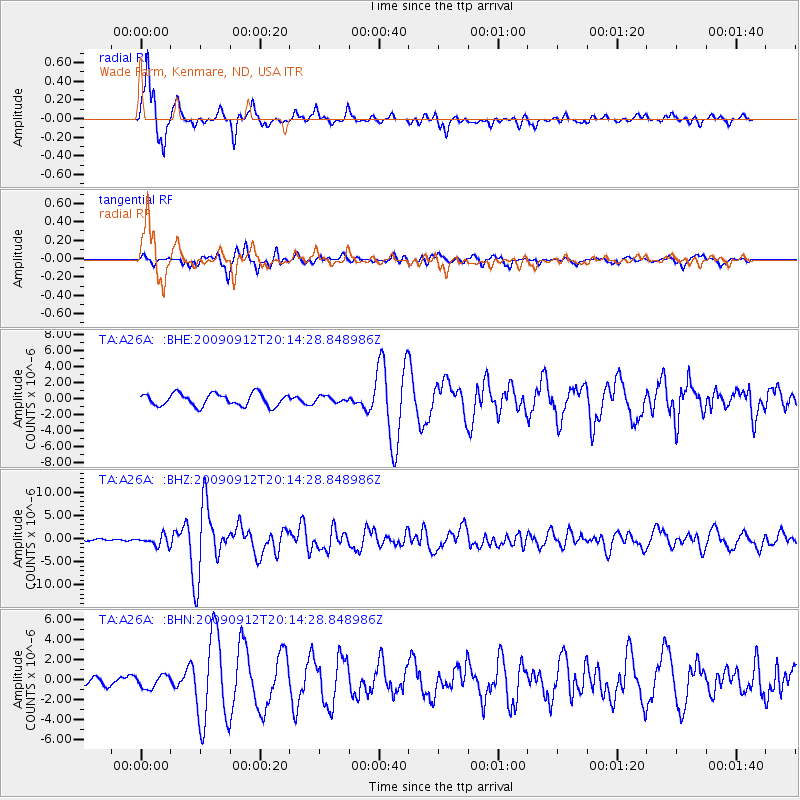
A26A Wade Farm, Kenmare, ND, USA - Earthquake Result Viewer

| Earthquake location: |
Near Coast Of Venezuela |
| Earthquake latitude/longitude: |
10.7/-67.9 |
| Earthquake time(UTC): |
2009/09/12 (255) 20:06:24 GMT |
| Earthquake Depth: |
10 km |
| Earthquake Magnitude: |
6.3 MB, 6.4 MS, 6.3 MW, 6.3 MW |
| Earthquake Catalog/Contributor: |
WHDF/NEIC |
|
| Network: |
TA USArray Transportable Network (new EarthScope stations) |
| Station: |
A26A Wade Farm, Kenmare, ND, USA |
| Lat/Lon: |
48.90 N/102.04 W |
| Elevation: |
570 m |
|
| Distance: |
47.5 deg |
| Az: |
329.864 deg |
| Baz: |
131.607 deg |
| Ray Param: |
0.06994951 |
| Estimated Moho Depth: |
45.75 km |
| Estimated Crust Vp/Vs: |
1.81 |
| Assumed Crust Vp: |
6.438 km/s |
| Estimated Crust Vs: |
3.552 km/s |
| Estimated Crust Poisson's Ratio: |
0.28 |
|
| Radial Match: |
93.29063 % |
| Radial Bump: |
320 |
| Transverse Match: |
77.223724 % |
| Transverse Bump: |
400 |
| SOD ConfigId: |
2622 |
| Insert Time: |
2010-03-07 06:11:21.572 +0000 |
| GWidth: |
2.5 |
| Max Bumps: |
400 |
| Tol: |
0.001 |
|
Signal To Noise
| Channel | StoN | STA | LTA |
| TA:A26A: :BHZ:20090912T20:14:28.848986Z | 3.5018 | 1.097153E-6 | 3.1331118E-7 |
| TA:A26A: :BHN:20090912T20:14:28.848986Z | 1.2363838 | 6.4846495E-7 | 5.244852E-7 |
| TA:A26A: :BHE:20090912T20:14:28.848986Z | 0.47824484 | 3.690289E-7 | 7.716318E-7 |
| Arrivals |
| Ps | 6.1 SECOND |
| PpPs | 19 SECOND |
| PsPs/PpSs | 25 SECOND |


