You are here: Home > Network List > TA - USArray Transportable Network (new EarthScope stations) Stations List
> Station A26A Wade Farm, Kenmare, ND, USA > Earthquake Result Viewer
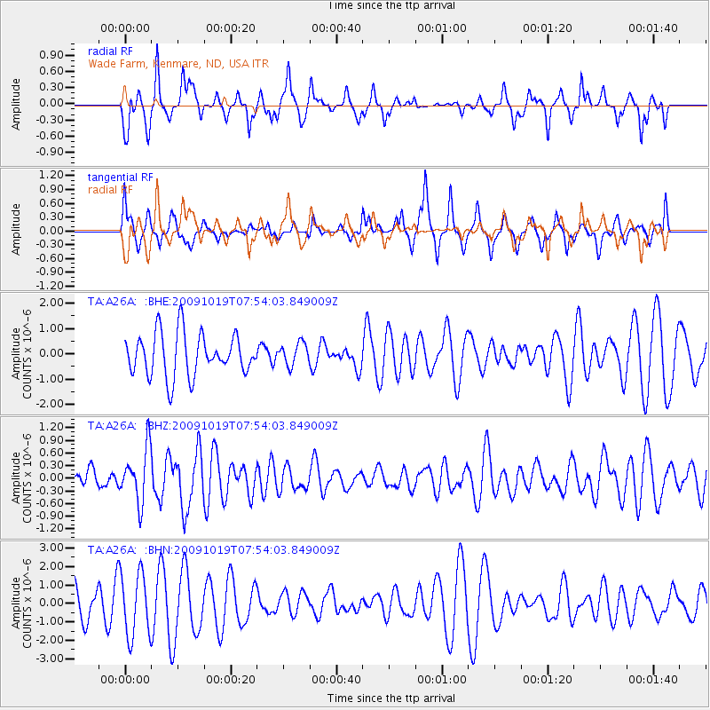
A26A Wade Farm, Kenmare, ND, USA - Earthquake Result Viewer
*The percent match for this event was below the threshold and hence no stack was calculated.
| Earthquake location: |
Samoa Islands Region |
| Earthquake latitude/longitude: |
-15.4/-173.0 |
| Earthquake time(UTC): |
2009/10/19 (292) 07:41:38 GMT |
| Earthquake Depth: |
10 km |
| Earthquake Magnitude: |
5.8 MW, 5.4 MS, 5.4 MB, 5.8 MW |
| Earthquake Catalog/Contributor: |
WHDF/NEIC |
|
| Network: |
TA USArray Transportable Network (new EarthScope stations) |
| Station: |
A26A Wade Farm, Kenmare, ND, USA |
| Lat/Lon: |
48.90 N/102.04 W |
| Elevation: |
570 m |
|
| Distance: |
89.5 deg |
| Az: |
38.591 deg |
| Baz: |
245.719 deg |
| Ray Param: |
$rayparam |
*The percent match for this event was below the threshold and hence was not used in the summary stack. |
|
| Radial Match: |
73.454346 % |
| Radial Bump: |
357 |
| Transverse Match: |
59.132286 % |
| Transverse Bump: |
400 |
| SOD ConfigId: |
2622 |
| Insert Time: |
2010-03-07 06:11:45.488 +0000 |
| GWidth: |
2.5 |
| Max Bumps: |
400 |
| Tol: |
0.001 |
|
Signal To Noise
| Channel | StoN | STA | LTA |
| TA:A26A: :BHZ:20091019T07:54:03.849009Z | 2.4175673 | 6.3794647E-7 | 2.638795E-7 |
| TA:A26A: :BHN:20091019T07:54:03.849009Z | 2.5233605 | 1.7113905E-6 | 6.782188E-7 |
| TA:A26A: :BHE:20091019T07:54:03.849009Z | 0.5273087 | 4.4416748E-7 | 8.4232914E-7 |
| Arrivals |
| Ps | |
| PpPs | |
| PsPs/PpSs | |


