You are here: Home > Network List > II - Global Seismograph Network (GSN - IRIS/IDA) Stations List
> Station WRAB Tennant Creek, NT, Australia > Earthquake Result Viewer
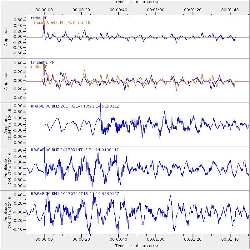
WRAB Tennant Creek, NT, Australia - Earthquake Result Viewer
*The percent match for this event was below the threshold and hence no stack was calculated.
| Earthquake location: |
Off W Coast Of Northern Sumatra |
| Earthquake latitude/longitude: |
3.6/95.9 |
| Earthquake time(UTC): |
2017/03/14 (073) 13:13:38 GMT |
| Earthquake Depth: |
41 km |
| Earthquake Magnitude: |
5.5 mb |
| Earthquake Catalog/Contributor: |
NEIC PDE/us |
|
| Network: |
II Global Seismograph Network (GSN - IRIS/IDA) |
| Station: |
WRAB Tennant Creek, NT, Australia |
| Lat/Lon: |
19.93 S/134.36 E |
| Elevation: |
366 m |
|
| Distance: |
44.5 deg |
| Az: |
123.297 deg |
| Baz: |
297.546 deg |
| Ray Param: |
$rayparam |
*The percent match for this event was below the threshold and hence was not used in the summary stack. |
|
| Radial Match: |
56.436234 % |
| Radial Bump: |
400 |
| Transverse Match: |
68.383354 % |
| Transverse Bump: |
400 |
| SOD ConfigId: |
1992691 |
| Insert Time: |
2017-03-28 13:16:16.898 +0000 |
| GWidth: |
2.5 |
| Max Bumps: |
400 |
| Tol: |
0.001 |
|
Signal To Noise
| Channel | StoN | STA | LTA |
| II:WRAB:00:BHZ:20170314T13:21:14.919011Z | 1.9608674 | 2.7430335E-7 | 1.3988877E-7 |
| II:WRAB:00:BH1:20170314T13:21:14.919011Z | 2.0525997 | 2.1694717E-7 | 1.0569386E-7 |
| II:WRAB:00:BH2:20170314T13:21:14.919011Z | 1.9435744 | 3.266926E-7 | 1.6808855E-7 |
| Arrivals |
| Ps | |
| PpPs | |
| PsPs/PpSs | |


