You are here: Home > Network List > GS - US Geological Survey Networks Stations List
> Station KAN14 Manchester OK Station > Earthquake Result Viewer
KAN14 Manchester OK Station - Earthquake Result Viewer
| Earthquake location: |
Andreanof Islands, Aleutian Is. |
| Earthquake latitude/longitude: |
51.2/-175.6 |
| Earthquake time(UTC): |
2019/11/24 (328) 00:54:03 GMT |
| Earthquake Depth: |
34 km |
| Earthquake Magnitude: |
5.6 Mi |
| Earthquake Catalog/Contributor: |
NEIC PDE/at |
|
| Network: |
GS US Geological Survey Networks |
| Station: |
KAN14 Manchester OK Station |
| Lat/Lon: |
36.96 N/97.96 W |
| Elevation: |
363 m |
|
| Distance: |
55.0 deg |
| Az: |
72.732 deg |
| Baz: |
311.395 deg |
| Ray Param: |
0.06500861 |
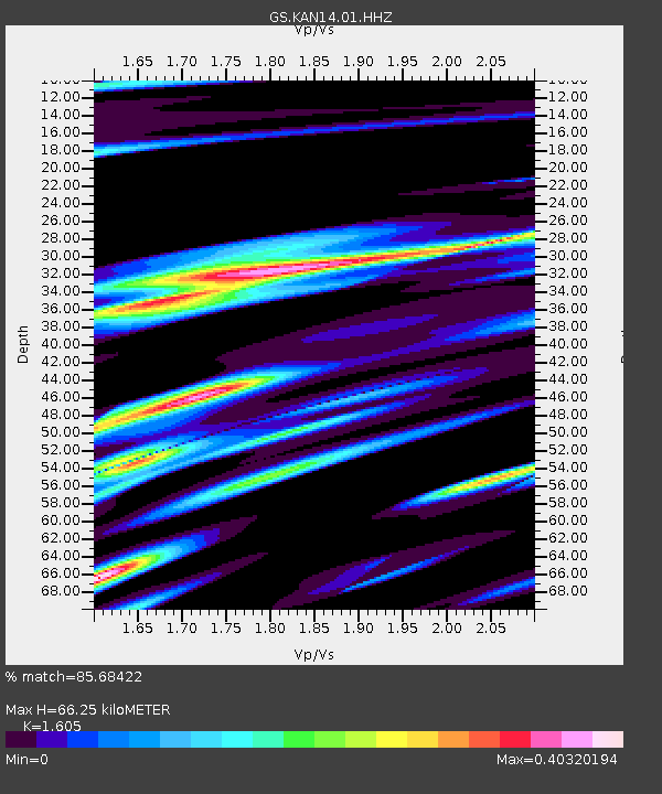
| Estimated Moho Depth: |
66.25 km |
| Estimated Crust Vp/Vs: |
1.61 |
| Assumed Crust Vp: |
6.483 km/s |
| Estimated Crust Vs: |
4.039 km/s |
| Estimated Crust Poisson's Ratio: |
0.18 |
|
| Radial Match: |
85.68422 % |
| Radial Bump: |
400 |
| Transverse Match: |
45.42132 % |
| Transverse Bump: |
400 |
| SOD ConfigId: |
19951751 |
| Insert Time: |
2019-12-08 01:03:32.755 +0000 |
| GWidth: |
2.5 |
| Max Bumps: |
400 |
| Tol: |
0.001 |
|

Signal To Noise
| Channel | StoN | STA | LTA |
| GS:KAN14:01:HHZ:20191124T01:03:00.450012Z | 7.857405 | 2.0222965E-6 | 2.573746E-7 |
| GS:KAN14:01:HHN:20191124T01:03:00.450012Z | 2.7185984 | 7.8317373E-7 | 2.8807997E-7 |
| GS:KAN14:01:HHE:20191124T01:03:00.450012Z | 4.8883934 | 7.8074686E-7 | 1.597144E-7 |
| Arrivals |
| Ps | 6.6 SECOND |
| PpPs | 25 SECOND |
| PsPs/PpSs | 32 SECOND |


