You are here: Home > Network List > IU - Global Seismograph Network (GSN - IRIS/USGS) Stations List
> Station PMG Port Moresby, New Guinea > Earthquake Result Viewer
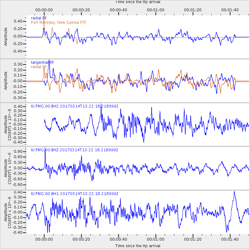
PMG Port Moresby, New Guinea - Earthquake Result Viewer
*The percent match for this event was below the threshold and hence no stack was calculated.
| Earthquake location: |
Off W Coast Of Northern Sumatra |
| Earthquake latitude/longitude: |
3.6/95.9 |
| Earthquake time(UTC): |
2017/03/14 (073) 13:13:38 GMT |
| Earthquake Depth: |
41 km |
| Earthquake Magnitude: |
5.5 mb |
| Earthquake Catalog/Contributor: |
NEIC PDE/us |
|
| Network: |
IU Global Seismograph Network (GSN - IRIS/USGS) |
| Station: |
PMG Port Moresby, New Guinea |
| Lat/Lon: |
9.40 S/147.16 E |
| Elevation: |
90 m |
|
| Distance: |
52.7 deg |
| Az: |
104.625 deg |
| Baz: |
281.86 deg |
| Ray Param: |
$rayparam |
*The percent match for this event was below the threshold and hence was not used in the summary stack. |
|
| Radial Match: |
62.558994 % |
| Radial Bump: |
400 |
| Transverse Match: |
63.503662 % |
| Transverse Bump: |
400 |
| SOD ConfigId: |
1992691 |
| Insert Time: |
2017-03-28 13:16:39.154 +0000 |
| GWidth: |
2.5 |
| Max Bumps: |
400 |
| Tol: |
0.001 |
|
Signal To Noise
| Channel | StoN | STA | LTA |
| IU:PMG:00:BHZ:20170314T13:22:18.218999Z | 2.9295259 | 2.981416E-7 | 1.0177128E-7 |
| IU:PMG:00:BH1:20170314T13:22:18.218999Z | 1.9767096 | 1.7677448E-7 | 8.942865E-8 |
| IU:PMG:00:BH2:20170314T13:22:18.218999Z | 1.5394858 | 1.4694362E-7 | 9.5449806E-8 |
| Arrivals |
| Ps | |
| PpPs | |
| PsPs/PpSs | |


