You are here: Home > Network List > TA - USArray Transportable Network (new EarthScope stations) Stations List
> Station C26A Wahner Farm, Parshall, ND, USA > Earthquake Result Viewer
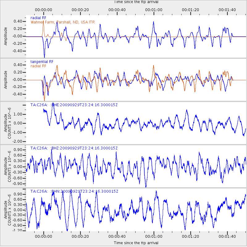
C26A Wahner Farm, Parshall, ND, USA - Earthquake Result Viewer
*The percent match for this event was below the threshold and hence no stack was calculated.
| Earthquake location: |
Tonga Islands |
| Earthquake latitude/longitude: |
-15.6/-173.4 |
| Earthquake time(UTC): |
2009/09/29 (272) 23:11:51 GMT |
| Earthquake Depth: |
10 km |
| Earthquake Magnitude: |
5.5 MB |
| Earthquake Catalog/Contributor: |
WHDF/NEIC |
|
| Network: |
TA USArray Transportable Network (new EarthScope stations) |
| Station: |
C26A Wahner Farm, Parshall, ND, USA |
| Lat/Lon: |
47.83 N/102.10 W |
| Elevation: |
656 m |
|
| Distance: |
89.4 deg |
| Az: |
39.66 deg |
| Baz: |
245.875 deg |
| Ray Param: |
$rayparam |
*The percent match for this event was below the threshold and hence was not used in the summary stack. |
|
| Radial Match: |
48.256584 % |
| Radial Bump: |
360 |
| Transverse Match: |
59.176216 % |
| Transverse Bump: |
390 |
| SOD ConfigId: |
2622 |
| Insert Time: |
2010-03-07 06:12:30.449 +0000 |
| GWidth: |
2.5 |
| Max Bumps: |
400 |
| Tol: |
0.001 |
|
Signal To Noise
| Channel | StoN | STA | LTA |
| TA:C26A: :BHZ:20090929T23:24:16.300015Z | 1.2253622 | 5.9971154E-7 | 4.8941575E-7 |
| TA:C26A: :BHN:20090929T23:24:16.300015Z | 0.9429576 | 5.0727243E-7 | 5.379589E-7 |
| TA:C26A: :BHE:20090929T23:24:16.300015Z | 1.1647283 | 7.8830993E-7 | 6.7681873E-7 |
| Arrivals |
| Ps | |
| PpPs | |
| PsPs/PpSs | |


