You are here: Home > Network List > KO - Kandilli Observatory Digital Broadband Seismic Network Stations List
> Station ELL Elmali-Antalya-Turkey > Earthquake Result Viewer
ELL Elmali-Antalya-Turkey - Earthquake Result Viewer
| Earthquake location: |
Andreanof Islands, Aleutian Is. |
| Earthquake latitude/longitude: |
51.2/-175.6 |
| Earthquake time(UTC): |
2019/11/24 (328) 00:54:03 GMT |
| Earthquake Depth: |
34 km |
| Earthquake Magnitude: |
5.6 Mi |
| Earthquake Catalog/Contributor: |
NEIC PDE/at |
|
| Network: |
KO Kandilli Observatory Digital Broadband Seismic Network |
| Station: |
ELL Elmali-Antalya-Turkey |
| Lat/Lon: |
36.75 N/29.91 E |
| Elevation: |
1230 m |
|
| Distance: |
89.6 deg |
| Az: |
339.778 deg |
| Baz: |
15.712 deg |
| Ray Param: |
0.04172808 |
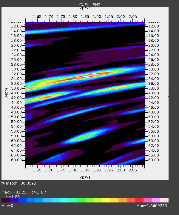
| Estimated Moho Depth: |
32.25 km |
| Estimated Crust Vp/Vs: |
1.88 |
| Assumed Crust Vp: |
6.12 km/s |
| Estimated Crust Vs: |
3.255 km/s |
| Estimated Crust Poisson's Ratio: |
0.30 |
|
| Radial Match: |
80.3598 % |
| Radial Bump: |
400 |
| Transverse Match: |
79.304924 % |
| Transverse Bump: |
400 |
| SOD ConfigId: |
19951751 |
| Insert Time: |
2019-12-08 01:04:35.267 +0000 |
| GWidth: |
2.5 |
| Max Bumps: |
400 |
| Tol: |
0.001 |
|

Signal To Noise
| Channel | StoN | STA | LTA |
| KO:ELL: :BHZ:20191124T01:06:25.960022Z | 12.014582 | 3.1405357E-6 | 2.6139367E-7 |
| KO:ELL: :BHN:20191124T01:06:25.960022Z | 3.065884 | 8.6231637E-7 | 2.812619E-7 |
| KO:ELL: :BHE:20191124T01:06:25.960022Z | 1.2789528 | 3.32437E-7 | 2.5992907E-7 |
| Arrivals |
| Ps | 4.7 SECOND |
| PpPs | 15 SECOND |
| PsPs/PpSs | 20 SECOND |


