You are here: Home > Network List > TA - USArray Transportable Network (new EarthScope stations) Stations List
> Station C26A Wahner Farm, Parshall, ND, USA > Earthquake Result Viewer
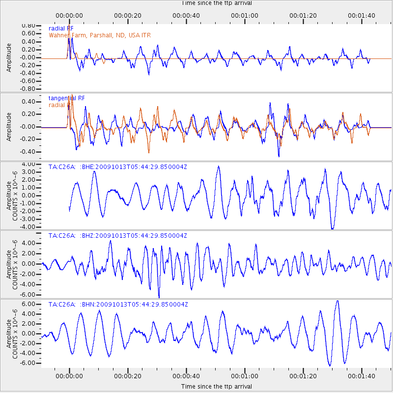
C26A Wahner Farm, Parshall, ND, USA - Earthquake Result Viewer
*The percent match for this event was below the threshold and hence no stack was calculated.
| Earthquake location: |
Fox Islands, Aleutian Islands |
| Earthquake latitude/longitude: |
52.8/-167.0 |
| Earthquake time(UTC): |
2009/10/13 (286) 05:37:23 GMT |
| Earthquake Depth: |
24 km |
| Earthquake Magnitude: |
6.0 MB, 6.1 MS, 6.5 MW, 6.5 MW |
| Earthquake Catalog/Contributor: |
WHDF/NEIC |
|
| Network: |
TA USArray Transportable Network (new EarthScope stations) |
| Station: |
C26A Wahner Farm, Parshall, ND, USA |
| Lat/Lon: |
47.83 N/102.10 W |
| Elevation: |
656 m |
|
| Distance: |
40.5 deg |
| Az: |
70.0 deg |
| Baz: |
302.05 deg |
| Ray Param: |
$rayparam |
*The percent match for this event was below the threshold and hence was not used in the summary stack. |
|
| Radial Match: |
60.745514 % |
| Radial Bump: |
352 |
| Transverse Match: |
57.50453 % |
| Transverse Bump: |
391 |
| SOD ConfigId: |
2622 |
| Insert Time: |
2010-03-07 06:12:33.132 +0000 |
| GWidth: |
2.5 |
| Max Bumps: |
400 |
| Tol: |
0.001 |
|
Signal To Noise
| Channel | StoN | STA | LTA |
| TA:C26A: :BHZ:20091013T05:44:29.850004Z | 2.1932342 | 8.933537E-7 | 4.0732252E-7 |
| TA:C26A: :BHN:20091013T05:44:29.850004Z | 1.7276983 | 2.8776408E-6 | 1.6655922E-6 |
| TA:C26A: :BHE:20091013T05:44:29.850004Z | 0.7836014 | 1.0387658E-6 | 1.3256304E-6 |
| Arrivals |
| Ps | |
| PpPs | |
| PsPs/PpSs | |


