You are here: Home > Network List > LD - Lamont-Doherty Cooperative Seismographic Network Stations List
> Station MVL Millersville University, PA > Earthquake Result Viewer
MVL Millersville University, PA - Earthquake Result Viewer
| Earthquake location: |
Andreanof Islands, Aleutian Is. |
| Earthquake latitude/longitude: |
51.2/-175.6 |
| Earthquake time(UTC): |
2019/11/24 (328) 00:54:03 GMT |
| Earthquake Depth: |
34 km |
| Earthquake Magnitude: |
5.6 Mi |
| Earthquake Catalog/Contributor: |
NEIC PDE/at |
|
| Network: |
LD Lamont-Doherty Cooperative Seismographic Network |
| Station: |
MVL Millersville University, PA |
| Lat/Lon: |
40.00 N/76.35 W |
| Elevation: |
91 m |
|
| Distance: |
65.2 deg |
| Az: |
56.669 deg |
| Baz: |
316.809 deg |
| Ray Param: |
0.0583974 |
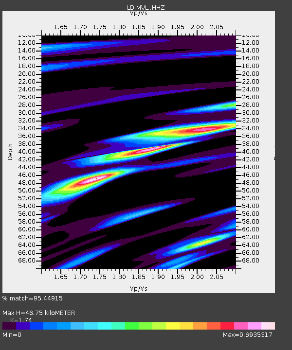
| Estimated Moho Depth: |
46.75 km |
| Estimated Crust Vp/Vs: |
1.74 |
| Assumed Crust Vp: |
6.419 km/s |
| Estimated Crust Vs: |
3.689 km/s |
| Estimated Crust Poisson's Ratio: |
0.25 |
|
| Radial Match: |
95.44915 % |
| Radial Bump: |
288 |
| Transverse Match: |
72.5658 % |
| Transverse Bump: |
400 |
| SOD ConfigId: |
19951751 |
| Insert Time: |
2019-12-08 01:05:01.481 +0000 |
| GWidth: |
2.5 |
| Max Bumps: |
400 |
| Tol: |
0.001 |
|

Signal To Noise
| Channel | StoN | STA | LTA |
| LD:MVL: :HHZ:20191124T01:04:09.830017Z | 14.463709 | 3.478604E-6 | 2.4050567E-7 |
| LD:MVL: :HHN:20191124T01:04:09.830017Z | 6.48684 | 1.3580368E-6 | 2.093526E-7 |
| LD:MVL: :HHE:20191124T01:04:09.830017Z | 4.4394155 | 9.887232E-7 | 2.2271472E-7 |
| Arrivals |
| Ps | 5.6 SECOND |
| PpPs | 19 SECOND |
| PsPs/PpSs | 25 SECOND |


