You are here: Home > Network List > TS - TERRAscope (Southern California Seismic Network) Stations List
> Station PAS Pasadena, California, USA > Earthquake Result Viewer
PAS Pasadena, California, USA - Earthquake Result Viewer
| Earthquake location: |
Kuril Islands |
| Earthquake latitude/longitude: |
48.8/154.5 |
| Earthquake time(UTC): |
1995/06/29 (180) 07:45:09 GMT |
| Earthquake Depth: |
62 km |
| Earthquake Magnitude: |
5.9 MB, 6.0 UNKNOWN, 6.0 MW |
| Earthquake Catalog/Contributor: |
WHDF/NEIC |
|
| Network: |
TS TERRAscope (Southern California Seismic Network) |
| Station: |
PAS Pasadena, California, USA |
| Lat/Lon: |
34.15 N/118.17 W |
| Elevation: |
295 m |
|
| Distance: |
63.6 deg |
| Az: |
67.627 deg |
| Baz: |
312.483 deg |
| Ray Param: |
0.0593091 |
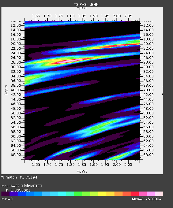
| Estimated Moho Depth: |
27.0 km |
| Estimated Crust Vp/Vs: |
1.81 |
| Assumed Crust Vp: |
6.1 km/s |
| Estimated Crust Vs: |
3.38 km/s |
| Estimated Crust Poisson's Ratio: |
0.28 |
|
| Radial Match: |
91.73194 % |
| Radial Bump: |
400 |
| Transverse Match: |
84.14779 % |
| Transverse Bump: |
400 |
| SOD ConfigId: |
6273 |
| Insert Time: |
2010-02-26 14:36:09.793 +0000 |
| GWidth: |
2.5 |
| Max Bumps: |
400 |
| Tol: |
0.001 |
|

Signal To Noise
| Channel | StoN | STA | LTA |
| TS:PAS: :BHN:19950629T07:55:03.457019Z | 3.4311097 | 3.4532357E-7 | 1.0064487E-7 |
| TS:PAS: :BHE:19950629T07:55:03.457019Z | 5.5118876 | 5.363388E-7 | 9.7305836E-8 |
| TS:PAS: :BHZ:19950629T07:55:03.457019Z | 20.216078 | 1.8496469E-6 | 9.149385E-8 |
| Arrivals |
| Ps | 3.7 SECOND |
| PpPs | 12 SECOND |
| PsPs/PpSs | 16 SECOND |


