You are here: Home > Network List > N4 - Central and EAstern US Network Stations List
> Station O48B Farmland, IN, USA > Earthquake Result Viewer
O48B Farmland, IN, USA - Earthquake Result Viewer
| Earthquake location: |
Andreanof Islands, Aleutian Is. |
| Earthquake latitude/longitude: |
51.2/-175.6 |
| Earthquake time(UTC): |
2019/11/24 (328) 00:54:03 GMT |
| Earthquake Depth: |
34 km |
| Earthquake Magnitude: |
5.6 Mi |
| Earthquake Catalog/Contributor: |
NEIC PDE/at |
|
| Network: |
N4 Central and EAstern US Network |
| Station: |
O48B Farmland, IN, USA |
| Lat/Lon: |
40.26 N/85.16 W |
| Elevation: |
300 m |
|
| Distance: |
60.2 deg |
| Az: |
61.85 deg |
| Baz: |
313.531 deg |
| Ray Param: |
0.061617825 |
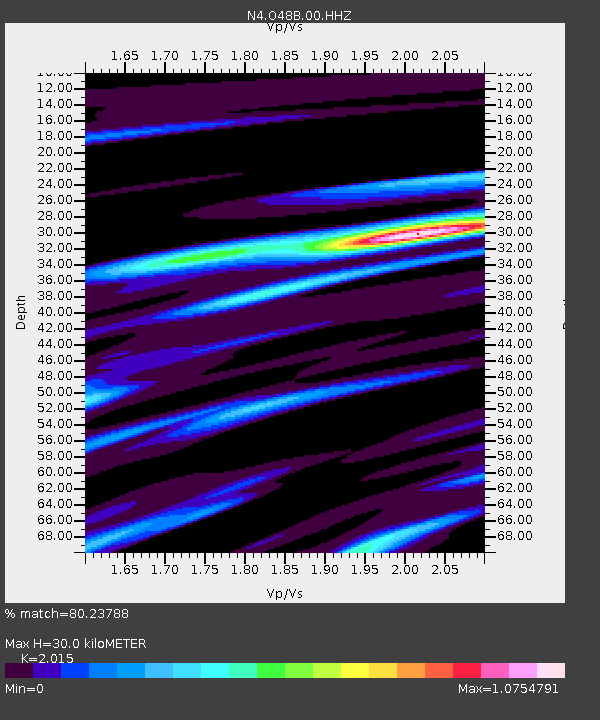
| Estimated Moho Depth: |
30.0 km |
| Estimated Crust Vp/Vs: |
2.02 |
| Assumed Crust Vp: |
6.498 km/s |
| Estimated Crust Vs: |
3.225 km/s |
| Estimated Crust Poisson's Ratio: |
0.34 |
|
| Radial Match: |
80.23788 % |
| Radial Bump: |
400 |
| Transverse Match: |
38.989075 % |
| Transverse Bump: |
400 |
| SOD ConfigId: |
19951751 |
| Insert Time: |
2019-12-08 01:06:12.706 +0000 |
| GWidth: |
2.5 |
| Max Bumps: |
400 |
| Tol: |
0.001 |
|

Signal To Noise
| Channel | StoN | STA | LTA |
| N4:O48B:00:HHZ:20191124T01:03:36.960022Z | 7.5413313 | 2.736275E-6 | 3.6283714E-7 |
| N4:O48B:00:HH1:20191124T01:03:36.960022Z | 4.0478773 | 1.2433516E-6 | 3.0716137E-7 |
| N4:O48B:00:HH2:20191124T01:03:36.960022Z | 2.014254 | 9.15922E-7 | 4.547202E-7 |
| Arrivals |
| Ps | 4.9 SECOND |
| PpPs | 13 SECOND |
| PsPs/PpSs | 18 SECOND |


