You are here: Home > Network List > TS - TERRAscope (Southern California Seismic Network) Stations List
> Station PAS Pasadena, California, USA > Earthquake Result Viewer
PAS Pasadena, California, USA - Earthquake Result Viewer
| Earthquake location: |
Colombia |
| Earthquake latitude/longitude: |
5.1/-72.9 |
| Earthquake time(UTC): |
1995/01/19 (019) 15:05:03 GMT |
| Earthquake Depth: |
18 km |
| Earthquake Magnitude: |
6.4 MB, 6.6 MS, 6.5 UNKNOWN, 6.5 MW |
| Earthquake Catalog/Contributor: |
WHDF/NEIC |
|
| Network: |
TS TERRAscope (Southern California Seismic Network) |
| Station: |
PAS Pasadena, California, USA |
| Lat/Lon: |
34.15 N/118.17 W |
| Elevation: |
295 m |
|
| Distance: |
50.9 deg |
| Az: |
310.625 deg |
| Baz: |
114.267 deg |
| Ray Param: |
0.06773036 |
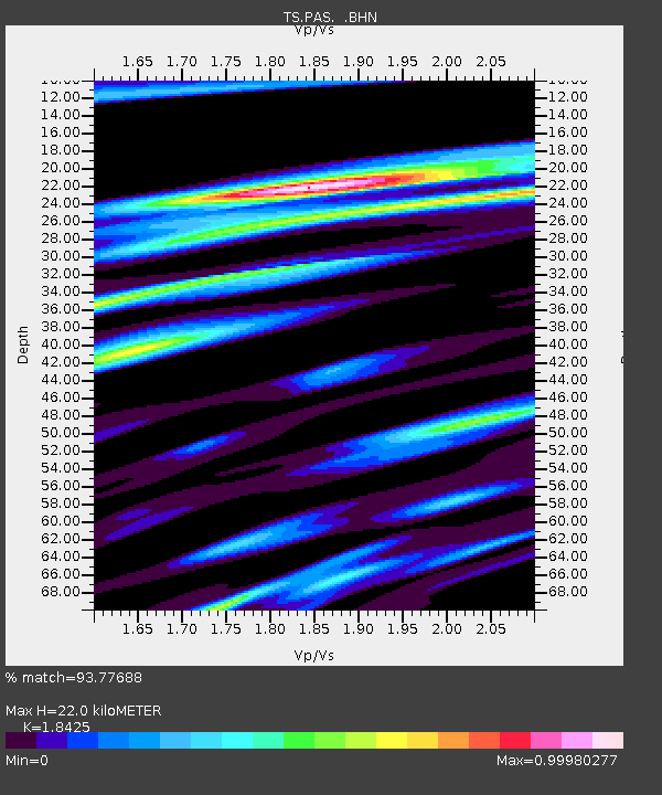
| Estimated Moho Depth: |
22.0 km |
| Estimated Crust Vp/Vs: |
1.84 |
| Assumed Crust Vp: |
6.1 km/s |
| Estimated Crust Vs: |
3.311 km/s |
| Estimated Crust Poisson's Ratio: |
0.29 |
|
| Radial Match: |
93.77688 % |
| Radial Bump: |
254 |
| Transverse Match: |
82.17067 % |
| Transverse Bump: |
304 |
| SOD ConfigId: |
6273 |
| Insert Time: |
2010-02-26 14:36:13.480 +0000 |
| GWidth: |
2.5 |
| Max Bumps: |
400 |
| Tol: |
0.001 |
|
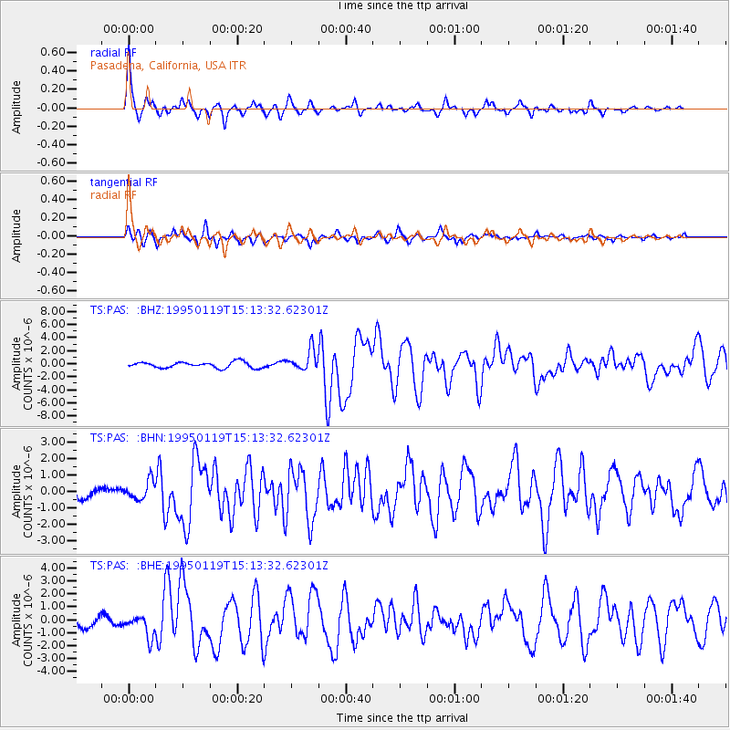
Signal To Noise
| Channel | StoN | STA | LTA |
| TS:PAS: :BHN:19950119T15:13:32.62301Z | 1.4893359 | 5.7124515E-7 | 3.8355694E-7 |
| TS:PAS: :BHE:19950119T15:13:32.62301Z | 2.74787 | 8.6454E-7 | 3.1462187E-7 |
| TS:PAS: :BHZ:19950119T15:13:32.62301Z | 3.629316 | 1.6218808E-6 | 4.468833E-7 |
| Arrivals |
| Ps | 3.2 SECOND |
| PpPs | 9.8 SECOND |
| PsPs/PpSs | 13 SECOND |


