You are here: Home > Network List > II - Global Seismograph Network (GSN - IRIS/IDA) Stations List
> Station WRAB Tennant Creek, NT, Australia > Earthquake Result Viewer
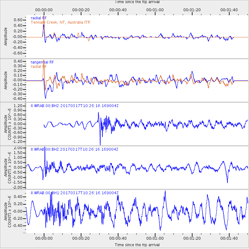
WRAB Tennant Creek, NT, Australia - Earthquake Result Viewer
*The percent match for this event was below the threshold and hence no stack was calculated.
| Earthquake location: |
South Of Fiji Islands |
| Earthquake latitude/longitude: |
-23.6/-176.8 |
| Earthquake time(UTC): |
2017/03/17 (076) 10:18:39 GMT |
| Earthquake Depth: |
109 km |
| Earthquake Magnitude: |
5.5 mb |
| Earthquake Catalog/Contributor: |
NEIC PDE/us |
|
| Network: |
II Global Seismograph Network (GSN - IRIS/IDA) |
| Station: |
WRAB Tennant Creek, NT, Australia |
| Lat/Lon: |
19.93 S/134.36 E |
| Elevation: |
366 m |
|
| Distance: |
45.4 deg |
| Az: |
264.804 deg |
| Baz: |
103.836 deg |
| Ray Param: |
$rayparam |
*The percent match for this event was below the threshold and hence was not used in the summary stack. |
|
| Radial Match: |
62.717155 % |
| Radial Bump: |
400 |
| Transverse Match: |
56.677586 % |
| Transverse Bump: |
400 |
| SOD ConfigId: |
1992691 |
| Insert Time: |
2017-03-31 10:20:21.054 +0000 |
| GWidth: |
2.5 |
| Max Bumps: |
400 |
| Tol: |
0.001 |
|
Signal To Noise
| Channel | StoN | STA | LTA |
| II:WRAB:00:BHZ:20170317T10:26:16.169004Z | 1.9081045 | 5.6743227E-7 | 2.9738007E-7 |
| II:WRAB:00:BH1:20170317T10:26:16.169004Z | 0.7699216 | 1.9310164E-7 | 2.508069E-7 |
| II:WRAB:00:BH2:20170317T10:26:16.169004Z | 3.2634544 | 4.1381736E-7 | 1.2680349E-7 |
| Arrivals |
| Ps | |
| PpPs | |
| PsPs/PpSs | |


