You are here: Home > Network List > O2 - Oklahoma Consolidated Temporary Seismic Networks Stations List
> Station SC07 Cyril, Oklahoma, USA > Earthquake Result Viewer
SC07 Cyril, Oklahoma, USA - Earthquake Result Viewer
| Earthquake location: |
Andreanof Islands, Aleutian Is. |
| Earthquake latitude/longitude: |
51.2/-175.6 |
| Earthquake time(UTC): |
2019/11/24 (328) 00:54:03 GMT |
| Earthquake Depth: |
34 km |
| Earthquake Magnitude: |
5.6 Mi |
| Earthquake Catalog/Contributor: |
NEIC PDE/at |
|
| Network: |
O2 Oklahoma Consolidated Temporary Seismic Networks |
| Station: |
SC07 Cyril, Oklahoma, USA |
| Lat/Lon: |
34.93 N/98.21 W |
| Elevation: |
349 m |
|
| Distance: |
56.2 deg |
| Az: |
74.718 deg |
| Baz: |
312.37 deg |
| Ray Param: |
0.06422679 |
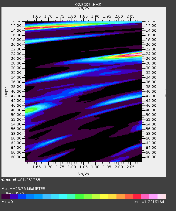
| Estimated Moho Depth: |
23.75 km |
| Estimated Crust Vp/Vs: |
2.10 |
| Assumed Crust Vp: |
6.315 km/s |
| Estimated Crust Vs: |
3.011 km/s |
| Estimated Crust Poisson's Ratio: |
0.35 |
|
| Radial Match: |
81.261765 % |
| Radial Bump: |
400 |
| Transverse Match: |
68.83252 % |
| Transverse Bump: |
400 |
| SOD ConfigId: |
19951751 |
| Insert Time: |
2019-12-08 01:07:47.088 +0000 |
| GWidth: |
2.5 |
| Max Bumps: |
400 |
| Tol: |
0.001 |
|

Signal To Noise
| Channel | StoN | STA | LTA |
| O2:SC07: :HHZ:20191124T01:03:09.025024Z | 8.062961 | 4.484697E-6 | 5.562097E-7 |
| O2:SC07: :HHN:20191124T01:03:09.025024Z | 1.3647299 | 1.6423801E-6 | 1.203447E-6 |
| O2:SC07: :HHE:20191124T01:03:09.025024Z | 1.4364212 | 1.5237679E-6 | 1.0608086E-6 |
| Arrivals |
| Ps | 4.3 SECOND |
| PpPs | 11 SECOND |
| PsPs/PpSs | 15 SECOND |


