You are here: Home > Network List > TS - TERRAscope (Southern California Seismic Network) Stations List
> Station PAS Pasadena, California, USA > Earthquake Result Viewer
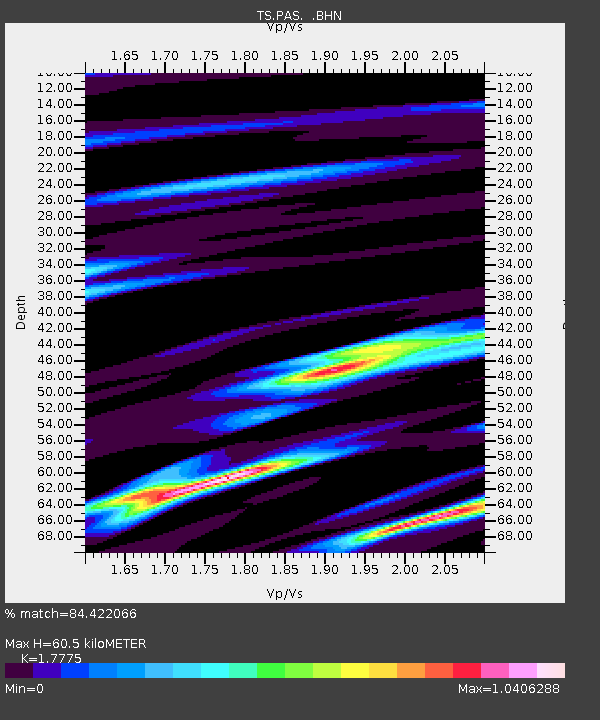
PAS Pasadena, California, USA - Earthquake Result Viewer
| Earthquake location: |
Southeast Of Loyalty Islands |
| Earthquake latitude/longitude: |
-22.8/169.9 |
| Earthquake time(UTC): |
1995/05/22 (142) 03:45:04 GMT |
| Earthquake Depth: |
33 km |
| Earthquake Magnitude: |
5.8 MB, 6.1 MS, 6.4 UNKNOWN, 6.1 MW |
| Earthquake Catalog/Contributor: |
WHDF/NEIC |
|
| Network: |
TS TERRAscope (Southern California Seismic Network) |
| Station: |
PAS Pasadena, California, USA |
| Lat/Lon: |
34.15 N/118.17 W |
| Elevation: |
295 m |
|
| Distance: |
88.7 deg |
| Az: |
52.044 deg |
| Baz: |
241.345 deg |
| Ray Param: |
0.042354222 |
| Estimated Moho Depth: |
60.5 km |
| Estimated Crust Vp/Vs: |
1.78 |
| Assumed Crust Vp: |
6.1 km/s |
| Estimated Crust Vs: |
3.432 km/s |
| Estimated Crust Poisson's Ratio: |
0.27 |
|
| Radial Match: |
84.422066 % |
| Radial Bump: |
400 |
| Transverse Match: |
65.41601 % |
| Transverse Bump: |
400 |
| SOD ConfigId: |
6273 |
| Insert Time: |
2010-02-26 14:36:17.624 +0000 |
| GWidth: |
2.5 |
| Max Bumps: |
400 |
| Tol: |
0.001 |
|

Signal To Noise
| Channel | StoN | STA | LTA |
| TS:PAS: :BHN:19950522T03:57:23.46001Z | 1.07039 | 1.3920611E-7 | 1.3005177E-7 |
| TS:PAS: :BHE:19950522T03:57:23.462024Z | 0.75249636 | 8.779391E-8 | 1.1667021E-7 |
| TS:PAS: :BHZ:19950522T03:57:23.462024Z | 3.1532884 | 3.420904E-7 | 1.0848688E-7 |
| Arrivals |
| Ps | 7.9 SECOND |
| PpPs | 27 SECOND |
| PsPs/PpSs | 35 SECOND |


