You are here: Home > Network List > TJ - Tajikistan National Seismic Network Stations List
> Station GARM Garm, Tajikistan > Earthquake Result Viewer
GARM Garm, Tajikistan - Earthquake Result Viewer
| Earthquake location: |
Andreanof Islands, Aleutian Is. |
| Earthquake latitude/longitude: |
51.2/-175.6 |
| Earthquake time(UTC): |
2019/11/24 (328) 00:54:03 GMT |
| Earthquake Depth: |
34 km |
| Earthquake Magnitude: |
5.6 Mi |
| Earthquake Catalog/Contributor: |
NEIC PDE/at |
|
| Network: |
TJ Tajikistan National Seismic Network |
| Station: |
GARM Garm, Tajikistan |
| Lat/Lon: |
39.00 N/70.32 E |
| Elevation: |
1305 m |
|
| Distance: |
73.3 deg |
| Az: |
312.057 deg |
| Baz: |
36.842 deg |
| Ray Param: |
0.053026035 |
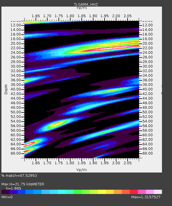
| Estimated Moho Depth: |
21.75 km |
| Estimated Crust Vp/Vs: |
1.99 |
| Assumed Crust Vp: |
6.306 km/s |
| Estimated Crust Vs: |
3.177 km/s |
| Estimated Crust Poisson's Ratio: |
0.33 |
|
| Radial Match: |
87.52953 % |
| Radial Bump: |
400 |
| Transverse Match: |
89.66936 % |
| Transverse Bump: |
400 |
| SOD ConfigId: |
19951751 |
| Insert Time: |
2019-12-08 01:10:20.656 +0000 |
| GWidth: |
2.5 |
| Max Bumps: |
400 |
| Tol: |
0.001 |
|
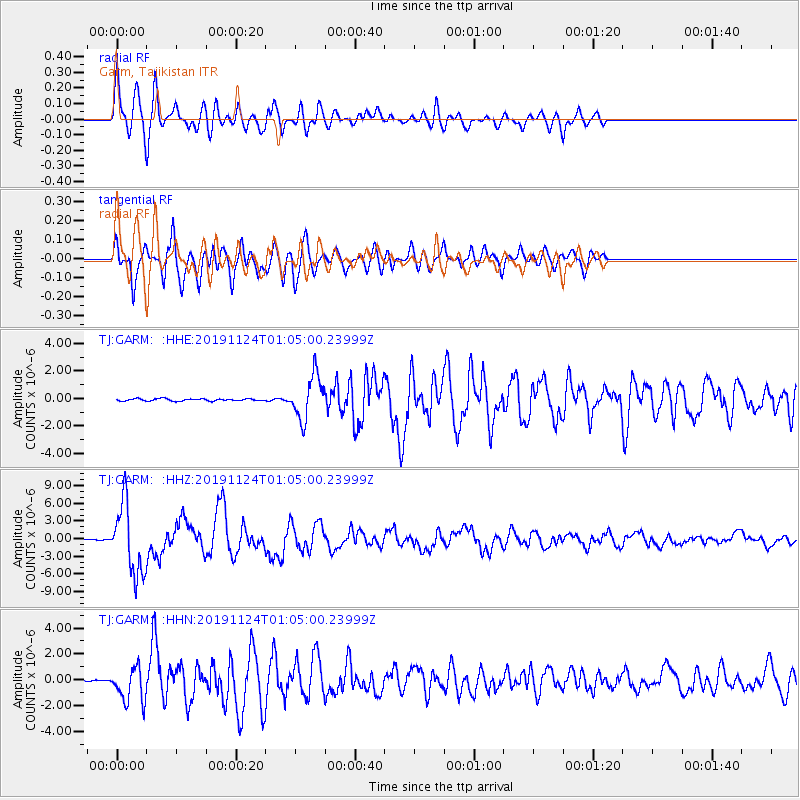
Signal To Noise
| Channel | StoN | STA | LTA |
| TJ:GARM: :HHZ:20191124T01:05:00.23999Z | 56.9462 | 5.902951E-6 | 1.0365839E-7 |
| TJ:GARM: :HHN:20191124T01:05:00.23999Z | 21.204737 | 1.3459787E-6 | 6.3475376E-8 |
| TJ:GARM: :HHE:20191124T01:05:00.23999Z | 20.129322 | 1.577411E-6 | 7.836385E-8 |
| Arrivals |
| Ps | 3.5 SECOND |
| PpPs | 10.0 SECOND |
| PsPs/PpSs | 13 SECOND |


